Chaussy geodata
Chaussy (Île-de-France) is a populated place; located in France in Europe/Paris (GMT+2) time zone. With population of 638 people, there are 12704 cities with bigger population in this country. Compared to other cities in France, 82.7% of cities are located further ↓South; 60.6% of cities are located further →East and 67% of cities have higher elevation than Chaussy. Note1
Administrative division(s):
- Level 1: Île-de-France
- Level 2: Département du Val-d’Oise
- Level 3: Arrondissement de Pontoise
- Level 4: Chaussy


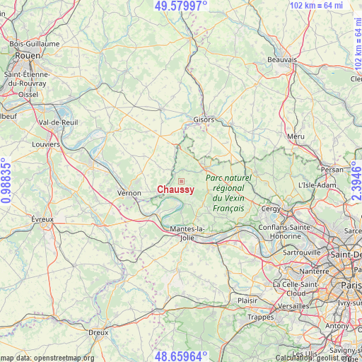
Chaussy GPS coordinates[2]
49° 7' 18.984" North, 1° 41' 29.328" East
| Map corner | latitude | longitude |
|---|---|---|
| Upper-left | 49.57997°, | 0.98835° |
| Center: | 49.12194°, | 1.69148° |
| Lower-right: | 48.65964°, | 2.3946° |
| Map W x H: | 102.3×102.3 km | = 63.6×63.6mi |
| max Lat: | 51.07786° ⇑17.3% North |
| Chaussy: | 49.12194° |
| min Lat: | ⇓82.7% South 41.3874° |
| min Long | Chaussy | max Long |
| -5.08615° | 1.69148° | 9.52242° |
| W 39.4%⇐ | ⇒60.6% E |
Elevation
Elevation of Chaussy is 85 m = 279 ft, and this is 108.7 m = 357 ft below average elevation for this country.
| Max E: |
2333 m = 7654 ft | 67% |
| Avg. | 193.7 m = 635 ft | |
| Chaussy | 85 m = 279 ft | |
Min E: |
-1 m = -3 ft | 33% |
See also: France elevation on elevation.city.
Geographical zone
Chaussy is located in North temperate zone (between Tropic of Cancer and the Arctic Circle). Distance of this North polar circle is 1939.3 km =1205 mi to North.| Distance of | km | miles | from Chaussy |
|---|---|---|---|
| North Pole | 4545.2 | 2824.3 | to North |
| Arctic Circle | 1939.3 | 1205 | to North |
| Tropic Cancer | 2855.9 | 1774.6 | to South |
| Equator | 5461.8 | 3393.8 | to South |


Nearby cities:
15 places around Chaussy: (largest is in red/bold)
• Aincourt
8.1 km =5 mi,  132°
132°
• Bray-et-Lû
3.1 km =1.9 mi,  304°
304°
• Château-sur-Epte
8.7 km =5.4 mi,  345°
345°
• Fourges
3.7 km =2.3 mi,  268°
268°
• Gasny
7.2 km =4.5 mi,  242°
242°
• Genainville
4.4 km =2.7 mi,  73°
73°
• Gommecourt
7.9 km =4.9 mi, 237°
• La Roche-Guyon
6.4 km =4 mi,  224°
224°
• Magny-en-Vexin
7.8 km =4.8 mi,  61°
61°
• Moisson
5.6 km =3.5 mi,  197°
197°
• Saint-Gervais
7.9 km =4.9 mi,  46°
46°
• Saint-Martin-la-Garenne
9 km =5.6 mi,  180°
180°
• Sainte-Geneviève-lès-Gasny
8.9 km =5.5 mi, 240°
• Vétheuil
6.7 km =4.2 mi,  172°
172°
• Écos
5.8 km =3.6 mi,  328°
328°
Sources, notices
• [Note1] Compared only with cities in France existing in our database
• [Src1] Map data: © OpenStreetMap contributors (CC-BY-SA)
• [Src2] Other city data from geonames.org with taken over terms of usage.
• [Src3] Geographical zone / Annual Mean Temperature by Robert A. Rohde @ Wikipedia
