Saint-Agathon geodata
Saint-Agathon (Brittany) is a populated place; located in France in Europe/Paris (GMT+2) time zone. With population of 1,876 people, there are 5081 cities with bigger population in this country. Compared to other cities in France, 69.8% of cities are located further ↓South; 97.5% of cities are located further →East and 54.8% of cities have higher elevation than Saint-Agathon. Note1
Administrative division(s):
- Level 1: Brittany
- Level 2: Département des Côtes-d’Armor
- Level 3: Arrondissement de Guingamp
- Level 4: Saint-Agathon


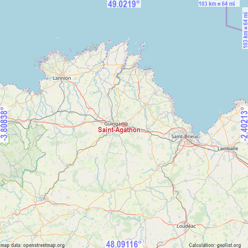
Saint-Agathon GPS coordinates[2]
48° 33' 31.212" North, 3° 6' 18.9" West
| Map corner | latitude | longitude |
|---|---|---|
| Upper-left | 49.0219°, | -3.80838° |
| Center: | 48.55867°, | -3.10525° |
| Lower-right: | 48.09116°, | -2.40213° |
| Map W x H: | 103.5×103.5 km | = 64.3×64.3mi |
| max Lat: | 51.07786° ⇑30.2% North |
| Saint-Agathon: | 48.55867° |
| min Lat: | ⇓69.8% South 41.3874° |
| min Long | Saint-Agathon | max Long |
| -5.08615° | -3.10525° | 9.52242° |
| W 2.5%⇐ | ⇒97.5% E |
Elevation
Elevation of Saint-Agathon is 117 m = 384 ft, and this is 76.7 m = 252 ft below average elevation for this country.
| Max E: |
2333 m = 7654 ft | 54.8% |
| Avg. | 193.7 m = 635 ft | |
| Saint-Agathon | 117 m = 384 ft | |
Min E: |
-1 m = -3 ft | 45.2% |
See also: France elevation on elevation.city.
Geographical zone
Saint-Agathon is located in North temperate zone (between Tropic of Cancer and the Arctic Circle). Distance of this North polar circle is 2002 km =1244 mi to North.| Distance of | km | miles | from Saint-Agathon |
|---|---|---|---|
| North Pole | 4607.8 | 2863.2 | to North |
| Arctic Circle | 2002 | 1244 | to North |
| Tropic Cancer | 2793.3 | 1735.7 | to South |
| Equator | 5399.2 | 3354.9 | to South |


Nearby cities:
15 places around Saint-Agathon: (largest is in red/bold)
• Châtelaudren
10 km =6.2 mi,  101°
101°
• Coadout
7.6 km =4.7 mi,  232°
232°
• Goudelin
8.1 km =5 mi,  51°
51°
• Grâces
5.9 km =3.7 mi,  267°
267°
• Guingamp
3.4 km =2.1 mi,  277°
277°
• Lanrodec
7.2 km =4.5 mi,  130°
130°
• Le Merzer
3.3 km =2.1 mi,  55°
55°
• Moustéru
10.9 km =6.8 mi,  245°
245°
• Pabu
3.8 km =2.4 mi,  323°
323°
• Plouagat
8.2 km =5.1 mi,  107°
107°
• Plouisy
6.2 km =3.9 mi,  290°
290°
• Ploumagoar
2.5 km =1.6 mi, 232°
• Pommerit-le-Vicomte
6.9 km =4.3 mi,  9°
9°
• Squiffiec
8.5 km =5.3 mi,  335°
335°
• Tressignaux
10.9 km =6.8 mi, 53°
Sources, notices
• [Note1] Compared only with cities in France existing in our database
• [Src1] Map data: © OpenStreetMap contributors (CC-BY-SA)
• [Src2] Other city data from geonames.org with taken over terms of usage.
• [Src3] Geographical zone / Annual Mean Temperature by Robert A. Rohde @ Wikipedia
