Lanrodec geodata
Lanrodec (Brittany) is a populated place; located in France in Europe/Paris (GMT+2) time zone. With population of 1,133 people, there are 7922 cities with bigger population in this country. Compared to other cities in France, 68.7% of cities are located further ↓South; 97.4% of cities are located further →East and 65.8% of cities have lower elevation than Lanrodec. Note1
Administrative division(s):
- Level 1: Brittany
- Level 2: Département des Côtes-d’Armor
- Level 3: Arrondissement de Guingamp
- Level 4: Lanrodec


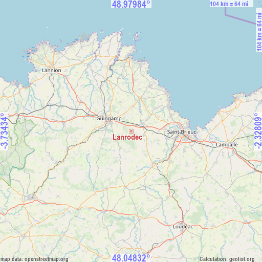
Lanrodec GPS coordinates[2]
48° 30' 58.392" North, 3° 1' 52.392" West
| Map corner | latitude | longitude |
|---|---|---|
| Upper-left | 48.97984°, | -3.73434° |
| Center: | 48.51622°, | -3.03122° |
| Lower-right: | 48.04832°, | -2.32809° |
| Map W x H: | 103.6×103.6 km | = 64.4×64.4mi |
| max Lat: | 51.07786° ⇑31.3% North |
| Lanrodec: | 48.51622° |
| min Lat: | ⇓68.7% South 41.3874° |
| min Long | Lanrodec | max Long |
| -5.08615° | -3.03122° | 9.52242° |
| W 2.6%⇐ | ⇒97.4% E |
Elevation
Elevation of Lanrodec is 198 m = 650 ft, and this is 4.3 m = 14 ft above average elevation for this country.
| Max E: |
2333 m = 7654 ft | 34.2% |
| Lanrodec | 198 m 650 ft | |
| Avg. | 193.7 m = 635 ft | |
Min E: |
-1 m = -3 ft | 65.8% |
See also: France elevation on elevation.city.
Geographical zone
Lanrodec is located in North temperate zone (between Tropic of Cancer and the Arctic Circle). Distance of this North polar circle is 2006.7 km =1246.9 mi to North.| Distance of | km | miles | from Lanrodec |
|---|---|---|---|
| North Pole | 4612.6 | 2866.1 | to North |
| Arctic Circle | 2006.7 | 1246.9 | to North |
| Tropic Cancer | 2788.6 | 1732.8 | to South |
| Equator | 5394.5 | 3352 | to South |


Nearby cities:
15 places around Lanrodec: (largest is in red/bold)
• Boqueho
6.3 km =3.9 mi,  125°
125°
• Châtelaudren
5.1 km =3.2 mi,  58°
58°
• Coadout
11.5 km =7.1 mi,  270°
270°
• Goudelin
9.8 km =6.1 mi,  5°
5°
• Guingamp
10.2 km =6.3 mi,  300°
300°
• Le Merzer
7.1 km =4.4 mi,  337°
337°
• Pabu
11 km =6.8 mi,  315°
315°
• Plerneuf
10.9 km =6.8 mi,  90°
90°
• Plouagat
3.2 km =2 mi,  46°
46°
• Ploumagoar
8.1 km =5 mi,  293°
293°
• Plouvara
8.6 km =5.3 mi,  96°
96°
• Plélo
7.6 km =4.7 mi, 55°
• Plésidy
10.1 km =6.3 mi,  220°
220°
• Saint-Agathon
7.2 km =4.5 mi,  310°
310°
• Tréguidel
11.5 km =7.1 mi,  34°
34°
Sources, notices
• [Note1] Compared only with cities in France existing in our database
• [Src1] Map data: © OpenStreetMap contributors (CC-BY-SA)
• [Src2] Other city data from geonames.org with taken over terms of usage.
• [Src3] Geographical zone / Annual Mean Temperature by Robert A. Rohde @ Wikipedia
