Saint-Affrique-les-Montagnes geodata
Saint-Affrique-les-Montagnes (Occitanie) is a populated place; located in France in Europe/Paris (GMT+2) time zone. With population of 637 people, there are 12716 cities with bigger population in this country. Compared to other cities in France, 92.6% of cities are located further ↑North; 54.3% of cities are located further →East and 73.3% of cities have lower elevation than Saint-Affrique-les-Montagnes. Note1
Administrative division(s):
- Level 1: Occitanie
- Level 2: Tarn
- Level 3: Arrondissement de Castres
- Level 4: Saint-Affrique-les-Montagnes
Current local time in Saint-Affrique-les-Montagnes:
03:25 AM, SundayDifference from your time zone: hours


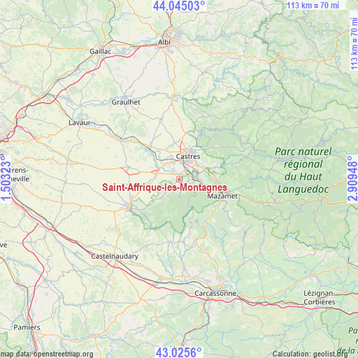
Saint-Affrique-les-Montagnes GPS coordinates[2]
43° 32' 14.892" North, 2° 12' 22.896" East
| Map corner | latitude | longitude |
|---|---|---|
| Upper-left | 44.04503°, | 1.50323° |
| Center: | 43.53747°, | 2.20636° |
| Lower-right: | 43.0256°, | 2.90948° |
| Map W x H: | 113.3×113.3 km | = 70.4×70.4mi |
| max Lat: | 51.07786° ⇑92.6% North |
| Saint-Affrique-les-Montagnes: | 43.53747° |
| min Lat: | ⇓7.4% South 41.3874° |
| min Long | Saint-Affrique- | max Long |
| -5.08615° | 2.20636° | 9.52242° |
| W 45.7%⇐ | ⇒54.3% E |
Elevation
Elevation of Saint-Affrique-les-Montagnes is 238 m = 781 ft, and this is 44.3 m = 145 ft above average elevation for this country.
| Max E: |
2333 m = 7654 ft | 26.7% |
| Saint-Affrique-les-Montagnes | 238 m 781 ft | |
| Avg. | 193.7 m = 635 ft | |
Min E: |
-1 m = -3 ft | 73.3% |
See also: France elevation on elevation.city.
Geographical zone
Saint-Affrique-les-Montagnes is located in North temperate zone (between Tropic of Cancer and the Arctic Circle). Distance of this Northern Tropic circle is 2235 km =1388.8 mi to South.| Distance of | km | miles | from Saint-Affrique-les-Montagnes |
|---|---|---|---|
| North Pole | 5166.1 | 3210.1 | to North |
| Arctic Circle | 2560.3 | 1590.9 | to North |
| Tropic Cancer | 2235 | 1388.8 | to South |
| Equator | 4840.9 | 3008 | to South |


Nearby cities:
15 places around Saint-Affrique-les-Montagnes: (largest is in red/bold)
• Aiguefonde
10.1 km =6.3 mi,  118°
118°
• Cambounet-sur-le-Sor
8.3 km =5.2 mi,  301°
301°
• Castres
8.1 km =5 mi,  19°
19°
• Dourgne
8 km =5 mi,  221°
221°
• Escoussens
4.2 km =2.6 mi,  171°
171°
• Fréjeville
9.7 km =6 mi,  327°
327°
• Labruguière
4.6 km =2.9 mi,  88°
88°
• Lagarrigue
7.3 km =4.5 mi,  52°
52°
• Navès
3.4 km =2.1 mi,  27°
27°
• Saïx
5.4 km =3.4 mi,  340°
340°
• Soual
7.5 km =4.7 mi,  285°
285°
• Sémalens
9.7 km =6 mi,  308°
308°
• Valdurenque
8.8 km =5.5 mi,  66°
66°
• Verdalle
4.8 km =3 mi,  231°
231°
• Viviers-lès-Montagnes
3.1 km =1.9 mi, 308°
Sources, notices
• [Note1] Compared only with cities in France existing in our database
• [Src1] Map data: © OpenStreetMap contributors (CC-BY-SA)
• [Src2] Other city data from geonames.org with taken over terms of usage.
• [Src3] Geographical zone / Annual Mean Temperature by Robert A. Rohde @ Wikipedia
