Navès geodata
Navès (Occitanie) is a populated place; located in France in Europe/Paris (GMT+2) time zone. With population of 745 people, there are 11223 cities with bigger population in this country. Compared to other cities in France, 92.3% of cities are located further ↑North; 54% of cities are located further →East and 71.4% of cities have lower elevation than Navès. Note1
Administrative division(s):
- Level 1: Occitanie
- Level 2: Tarn
- Level 3: Arrondissement de Castres
- Level 4: Navès


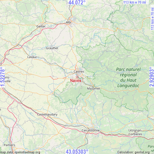
Navès GPS coordinates[2]
43° 33' 52.812" North, 2° 13' 33.24" East
| Map corner | latitude | longitude |
|---|---|---|
| Upper-left | 44.072°, | 1.52278° |
| Center: | 43.56467°, | 2.2259° |
| Lower-right: | 43.05303°, | 2.92903° |
| Map W x H: | 113.3×113.3 km | = 70.4×70.4mi |
| max Lat: | 51.07786° ⇑92.3% North |
| Navès: | 43.56467° |
| min Lat: | ⇓7.7% South 41.3874° |
| min Long | Navès | max Long |
| -5.08615° | 2.2259° | 9.52242° |
| W 46%⇐ | ⇒54% E |
Elevation
Elevation of Navès is 226 m = 741 ft, and this is 32.3 m = 106 ft above average elevation for this country.
| Max E: |
2333 m = 7654 ft | 28.6% |
| Navès | 226 m 741 ft | |
| Avg. | 193.7 m = 635 ft | |
Min E: |
-1 m = -3 ft | 71.4% |
See also: France elevation on elevation.city.
Geographical zone
Navès is located in North temperate zone (between Tropic of Cancer and the Arctic Circle). Distance of this Northern Tropic circle is 2238 km =1390.6 mi to South.| Distance of | km | miles | from Navès |
|---|---|---|---|
| North Pole | 5163.1 | 3208.2 | to North |
| Arctic Circle | 2557.2 | 1589 | to North |
| Tropic Cancer | 2238 | 1390.6 | to South |
| Equator | 4843.9 | 3009.9 | to South |


Nearby cities:
15 places around Navès: (largest is in red/bold)
• Cambounet-sur-le-Sor
8.8 km =5.5 mi,  278°
278°
• Castres
4.7 km =2.9 mi,  13°
13°
• Escoussens
7.2 km =4.5 mi,  187°
187°
• Fréjeville
8.5 km =5.3 mi,  306°
306°
• Labruguière
4.2 km =2.6 mi,  133°
133°
• Lagarrigue
4.4 km =2.7 mi,  70°
70°
• Noailhac
10.4 km =6.5 mi,  84°
84°
• Payrin-Augmontel
10.6 km =6.6 mi,  102°
102°
• Saint-Affrique-les-Montagnes
3.4 km =2.1 mi,  207°
207°
• Saïx
4 km =2.5 mi,  301°
301°
• Soual
8.9 km =5.5 mi,  263°
263°
• Sémalens
9.7 km =6 mi,  288°
288°
• Valdurenque
6.5 km =4 mi,  85°
85°
• Verdalle
8 km =5 mi,  221°
221°
• Viviers-lès-Montagnes
4.1 km =2.5 mi,  254°
254°
Sources, notices
• [Note1] Compared only with cities in France existing in our database
• [Src1] Map data: © OpenStreetMap contributors (CC-BY-SA)
• [Src2] Other city data from geonames.org with taken over terms of usage.
• [Src3] Geographical zone / Annual Mean Temperature by Robert A. Rohde @ Wikipedia
