Valdurenque geodata
Valdurenque (Occitanie) is a populated place; located in France in Europe/Paris (GMT+2) time zone. With population of 654 people, there are 12467 cities with bigger population in this country. Compared to other cities in France, 92.2% of cities are located further ↑North; 52.6% of cities are located further →East and 67.6% of cities have lower elevation than Valdurenque. Note1
Administrative division(s):
- Level 1: Occitanie
- Level 2: Tarn
- Level 3: Arrondissement de Castres
- Level 4: Valdurenque


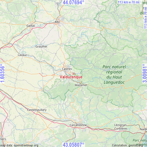
Valdurenque GPS coordinates[2]
43° 34' 10.776" North, 2° 18' 24.048" East
| Map corner | latitude | longitude |
|---|---|---|
| Upper-left | 44.07694°, | 1.60356° |
| Center: | 43.56966°, | 2.30668° |
| Lower-right: | 43.05807°, | 3.00981° |
| Map W x H: | 113.3×113.3 km | = 70.4×70.4mi |
| max Lat: | 51.07786° ⇑92.2% North |
| Valdurenque: | 43.56966° |
| min Lat: | ⇓7.8% South 41.3874° |
| min Long | Valdurenque | max Long |
| -5.08615° | 2.30668° | 9.52242° |
| W 47.4%⇐ | ⇒52.6% E |
Elevation
Elevation of Valdurenque is 207 m = 679 ft, and this is 13.3 m = 44 ft above average elevation for this country.
| Max E: |
2333 m = 7654 ft | 32.4% |
| Valdurenque | 207 m 679 ft | |
| Avg. | 193.7 m = 635 ft | |
Min E: |
-1 m = -3 ft | 67.6% |
See also: France elevation on elevation.city.
Geographical zone
Valdurenque is located in North temperate zone (between Tropic of Cancer and the Arctic Circle). Distance of this Northern Tropic circle is 2238.6 km =1391 mi to South.| Distance of | km | miles | from Valdurenque |
|---|---|---|---|
| North Pole | 5162.6 | 3207.9 | to North |
| Arctic Circle | 2556.7 | 1588.7 | to North |
| Tropic Cancer | 2238.6 | 1391 | to South |
| Equator | 4844.5 | 3010.2 | to South |


Nearby cities:
15 places around Valdurenque: (largest is in red/bold)
• Aiguefonde
8.5 km =5.3 mi,  174°
174°
• Aussillon
8.9 km =5.5 mi,  146°
146°
• Burlats
7.5 km =4.7 mi,  7°
7°
• Castres
6.7 km =4.2 mi,  306°
306°
• Labruguière
4.9 km =3 mi,  224°
224°
• Lacrouzette
10.6 km =6.6 mi,  18°
18°
• Lagarrigue
2.5 km =1.6 mi,  290°
290°
• Mazamet
10.3 km =6.4 mi, 148°
• Navès
6.5 km =4 mi,  265°
265°
• Noailhac
3.8 km =2.4 mi,  83°
83°
• Payrin-Augmontel
4.7 km =2.9 mi,  126°
126°
• Saint-Affrique-les-Montagnes
8.8 km =5.5 mi,  246°
246°
• Saint-Salvy-de-la-Balme
8.8 km =5.5 mi,  58°
58°
• Saïx
10.1 km =6.3 mi,  278°
278°
• Viviers-lès-Montagnes
10.6 km =6.6 mi,  260°
260°
Sources, notices
• [Note1] Compared only with cities in France existing in our database
• [Src1] Map data: © OpenStreetMap contributors (CC-BY-SA)
• [Src2] Other city data from geonames.org with taken over terms of usage.
• [Src3] Geographical zone / Annual Mean Temperature by Robert A. Rohde @ Wikipedia
