Castres geodata
Castres (Occitanie) is a seat of a third-order administrative division; located in France in Europe/Paris (GMT+2) time zone. With population of 47,275 people, there are 134 cities with bigger population in this country. Compared to other cities in France, 91.8% of cities are located further ↑North; 53.7% of cities are located further →East and 61.6% of cities have lower elevation than Castres. Note1
Administrative division(s):
- Level 1: Occitanie
- Level 2: Tarn
- Level 3: Arrondissement de Castres
- Level 4: Castres


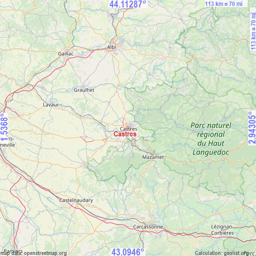
Castres GPS coordinates[2]
43° 36' 21.204" North, 2° 14' 23.712" East
| Map corner | latitude | longitude |
|---|---|---|
| Upper-left | 44.11287°, | 1.5368° |
| Center: | 43.60589°, | 2.23992° |
| Lower-right: | 43.0946°, | 2.94305° |
| Map W x H: | 113.2×113.2 km | = 70.3×70.3mi |
| max Lat: | 51.07786° ⇑91.8% North |
| Castres: | 43.60589° |
| min Lat: | ⇓8.2% South 41.3874° |
| min Long | Castres | max Long |
| -5.08615° | 2.23992° | 9.52242° |
| W 46.3%⇐ | ⇒53.7% E |
Elevation
Elevation of Castres is 178 m = 584 ft, and this is 15.7 m = 52 ft below average elevation for this country.
| Max E: |
2333 m = 7654 ft | 38.4% |
| Avg. | 193.7 m = 635 ft | |
| Castres | 178 m = 584 ft | |
Min E: |
-1 m = -3 ft | 61.6% |
See also: Castres elevation on elevation.city.
Geographical zone
Castres is located in North temperate zone (between Tropic of Cancer and the Arctic Circle). Distance of this Northern Tropic circle is 2242.6 km =1393.5 mi to South.| Distance of | km | miles | from Castres |
|---|---|---|---|
| North Pole | 5158.5 | 3205.3 | to North |
| Arctic Circle | 2552.7 | 1586.2 | to North |
| Tropic Cancer | 2242.6 | 1393.5 | to South |
| Equator | 4848.5 | 3012.7 | to South |


Nearby cities:
15 places around Castres: (largest is in red/bold)
• Burlats
7.2 km =4.5 mi,  61°
61°
• Cambounet-sur-le-Sor
10.3 km =6.4 mi,  251°
251°
• Fréjeville
8 km =5 mi,  273°
273°
• Labruguière
7.7 km =4.8 mi,  165°
165°
• Lacrouzette
10.6 km =6.6 mi, 55°
• Lagarrigue
4.4 km =2.7 mi,  135°
135°
• Navès
4.7 km =2.9 mi,  193°
193°
• Noailhac
9.9 km =6.2 mi,  111°
111°
• Roquecourbe
7.8 km =4.8 mi,  33°
33°
• Saint-Affrique-les-Montagnes
8.1 km =5 mi,  199°
199°
• Saïx
5.2 km =3.2 mi,  241°
241°
• Sémalens
10.4 km =6.5 mi,  261°
261°
• Valdurenque
6.7 km =4.2 mi,  126°
126°
• Vielmur-sur-Agout
11.3 km =7 mi,  276°
276°
• Viviers-lès-Montagnes
7.6 km =4.7 mi,  221°
221°
Sources, notices
• [Note1] Compared only with cities in France existing in our database
• [Src1] Map data: © OpenStreetMap contributors (CC-BY-SA)
• [Src2] Other city data from geonames.org with taken over terms of usage.
• [Src3] Geographical zone / Annual Mean Temperature by Robert A. Rohde @ Wikipedia
