Saffré geodata
Saffré (Pays de la Loire) is a populated place; located in France in Europe/Paris (GMT+2) time zone. With population of 2,884 people, there are 3382 cities with bigger population in this country. Compared to other cities in France, 51.3% of cities are located further ↓South; 92.8% of cities are located further →East and 91.2% of cities have higher elevation than Saffré. Note1
Administrative division(s):
- Level 1: Pays de la Loire
- Level 2: Loire-Atlantique
- Level 3: Arrondissement of Châteaubriant-Ancenis
- Level 4: Saffré


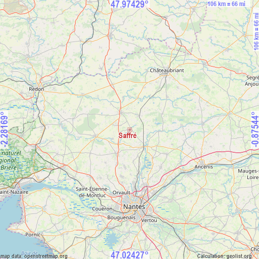
Saffré GPS coordinates[2]
47° 30' 5.148" North, 1° 34' 42.816" West
| Map corner | latitude | longitude |
|---|---|---|
| Upper-left | 47.97429°, | -2.28169° |
| Center: | 47.50143°, | -1.57856° |
| Lower-right: | 47.02427°, | -0.87544° |
| Map W x H: | 105.6×105.6 km | = 65.6×65.6mi |
| max Lat: | 51.07786° ⇑48.7% North |
| Saffré: | 47.50143° |
| min Lat: | ⇓51.3% South 41.3874° |
| min Long | Saffré | max Long |
| -5.08615° | -1.57856° | 9.52242° |
| W 7.2%⇐ | ⇒92.8% E |
Elevation
Elevation of Saffré is 27 m = 89 ft, and this is 166.7 m = 547 ft below average elevation for this country.
| Max E: |
2333 m = 7654 ft | 91.2% |
| Avg. | 193.7 m = 635 ft | |
| Saffré | 27 m = 89 ft | |
Min E: |
-1 m = -3 ft | 8.8% |
See also: France elevation on elevation.city.
Geographical zone
Saffré is located in North temperate zone (between Tropic of Cancer and the Arctic Circle). Distance of this North polar circle is 2119.5 km =1317 mi to North.| Distance of | km | miles | from Saffré |
|---|---|---|---|
| North Pole | 4725.4 | 2936.2 | to North |
| Arctic Circle | 2119.5 | 1317 | to North |
| Tropic Cancer | 2675.7 | 1662.6 | to South |
| Equator | 5281.7 | 3281.9 | to South |


Nearby cities:
15 places around Saffré: (largest is in red/bold)
• Abbaretz
6.7 km =4.2 mi,  31°
31°
• Bourg de Joué-sur-Erdre
11.9 km =7.4 mi,  92°
92°
• Casson
12.8 km =8 mi,  172°
172°
• Héric
11.2 km =7 mi,  210°
210°
• Jans
13.5 km =8.4 mi,  348°
348°
• La Chevallerais
7.8 km =4.8 mi,  242°
242°
• La Grigonnais
7.3 km =4.5 mi,  293°
293°
• Le Gâvre
13 km =8.1 mi,  279°
279°
• Les Touches
12.9 km =8 mi,  120°
120°
• Marsac-sur-Don
13 km =8.1 mi,  324°
324°
• Nort-sur-Erdre
9.2 km =5.7 mi,  139°
139°
• Nozay
7.9 km =4.9 mi,  333°
333°
• Puceul
3.7 km =2.3 mi,  308°
308°
• Treffieux
13.5 km =8.4 mi,  13°
13°
• Vay
10.9 km =6.8 mi,  302°
302°
Sources, notices
• [Note1] Compared only with cities in France existing in our database
• [Src1] Map data: © OpenStreetMap contributors (CC-BY-SA)
• [Src2] Other city data from geonames.org with taken over terms of usage.
• [Src3] Geographical zone / Annual Mean Temperature by Robert A. Rohde @ Wikipedia
