Vay geodata
Vay (Pays de la Loire) is a populated place; located in France in Europe/Paris (GMT+2) time zone. With population of 1,333 people, there are 6883 cities with bigger population in this country. Compared to other cities in France, 52.1% of cities are located further ↓South; 93.5% of cities are located further →East and 76.6% of cities have higher elevation than Vay. Note1
Administrative division(s):
- Level 1: Pays de la Loire
- Level 2: Loire-Atlantique
- Level 3: Arrondissement of Châteaubriant-Ancenis
- Level 4: Vay


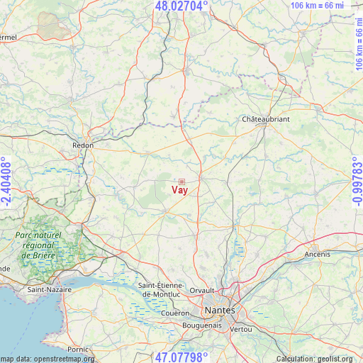
Vay GPS coordinates[2]
47° 33' 16.776" North, 1° 42' 3.42" West
| Map corner | latitude | longitude |
|---|---|---|
| Upper-left | 48.02704°, | -2.40408° |
| Center: | 47.55466°, | -1.70095° |
| Lower-right: | 47.07798°, | -0.99783° |
| Map W x H: | 105.5×105.5 km | = 65.6×65.6mi |
| max Lat: | 51.07786° ⇑47.9% North |
| Vay: | 47.55466° |
| min Lat: | ⇓52.1% South 41.3874° |
| min Long | Vay | max Long |
| -5.08615° | -1.70095° | 9.52242° |
| W 6.5%⇐ | ⇒93.5% E |
Elevation
Elevation of Vay is 63 m = 207 ft, and this is 130.7 m = 429 ft below average elevation for this country.
| Max E: |
2333 m = 7654 ft | 76.6% |
| Avg. | 193.7 m = 635 ft | |
| Vay | 63 m = 207 ft | |
Min E: |
-1 m = -3 ft | 23.4% |
See also: France elevation on elevation.city.
Geographical zone
Vay is located in North temperate zone (between Tropic of Cancer and the Arctic Circle). Distance of this North polar circle is 2113.6 km =1313.3 mi to North.| Distance of | km | miles | from Vay |
|---|---|---|---|
| North Pole | 4719.5 | 2932.6 | to North |
| Arctic Circle | 2113.6 | 1313.3 | to North |
| Tropic Cancer | 2681.7 | 1666.3 | to South |
| Equator | 5287.6 | 3285.6 | to South |


Nearby cities:
15 places around Vay: (largest is in red/bold)
• Abbaretz
12.7 km =7.9 mi,  90°
90°
• Blain
9.9 km =6.2 mi,  208°
208°
• Conquereuil
8.7 km =5.4 mi,  334°
334°
• Derval
12.7 km =7.9 mi,  10°
10°
• Guémené-Penfao
13.2 km =8.2 mi,  311°
311°
• Jans
9.8 km =6.1 mi,  41°
41°
• La Chevallerais
9.9 km =6.2 mi,  166°
166°
• La Grigonnais
3.9 km =2.4 mi,  140°
140°
• Le Gâvre
5.2 km =3.2 mi,  224°
224°
• Marsac-sur-Don
4.9 km =3 mi,  19°
19°
• Nozay
5.7 km =3.5 mi,  78°
78°
• Plessé
14 km =8.7 mi,  264°
264°
• Puceul
7.3 km =4.5 mi,  119°
119°
• Saffré
10.9 km =6.8 mi, 122°
• Treffieux
14.3 km =8.9 mi,  59°
59°
Sources, notices
• [Note1] Compared only with cities in France existing in our database
• [Src1] Map data: © OpenStreetMap contributors (CC-BY-SA)
• [Src2] Other city data from geonames.org with taken over terms of usage.
• [Src3] Geographical zone / Annual Mean Temperature by Robert A. Rohde @ Wikipedia
