Nozay geodata
Nozay (Pays de la Loire) is a populated place; located in France in Europe/Paris (GMT+2) time zone. With population of 3,419 people, there are 2847 cities with bigger population in this country. Compared to other cities in France, 52.2% of cities are located further ↓South; 93.1% of cities are located further →East and 80.6% of cities have higher elevation than Nozay. Note1
Administrative division(s):
- Level 1: Pays de la Loire
- Level 2: Loire-Atlantique
- Level 3: Arrondissement of Châteaubriant-Ancenis
- Level 4: Nozay


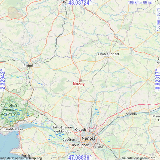
Nozay GPS coordinates[2]
47° 33' 53.82" North, 1° 37' 34.644" West
| Map corner | latitude | longitude |
|---|---|---|
| Upper-left | 48.03724°, | -2.32942° |
| Center: | 47.56495°, | -1.62629° |
| Lower-right: | 47.08836°, | -0.92317° |
| Map W x H: | 105.5×105.5 km | = 65.6×65.6mi |
| max Lat: | 51.07786° ⇑47.8% North |
| Nozay: | 47.56495° |
| min Lat: | ⇓52.2% South 41.3874° |
| min Long | Nozay | max Long |
| -5.08615° | -1.62629° | 9.52242° |
| W 6.9%⇐ | ⇒93.1% E |
Elevation
Elevation of Nozay is 53 m = 174 ft, and this is 140.7 m = 462 ft below average elevation for this country.
| Max E: |
2333 m = 7654 ft | 80.6% |
| Avg. | 193.7 m = 635 ft | |
| Nozay | 53 m = 174 ft | |
Min E: |
-1 m = -3 ft | 19.4% |
See also: France elevation on elevation.city.
Geographical zone
Nozay is located in North temperate zone (between Tropic of Cancer and the Arctic Circle). Distance of this North polar circle is 2112.4 km =1312.6 mi to North.| Distance of | km | miles | from Nozay |
|---|---|---|---|
| North Pole | 4718.3 | 2931.8 | to North |
| Arctic Circle | 2112.4 | 1312.6 | to North |
| Tropic Cancer | 2682.8 | 1667 | to South |
| Equator | 5288.7 | 3286.2 | to South |


Nearby cities:
15 places around Nozay: (largest is in red/bold)
• Abbaretz
7.2 km =4.5 mi,  100°
100°
• Blain
14.2 km =8.8 mi,  226°
226°
• Conquereuil
11.5 km =7.1 mi,  305°
305°
• Derval
11.8 km =7.3 mi,  343°
343°
• Jans
6.2 km =3.9 mi,  8°
8°
• La Chevallerais
11.2 km =7 mi,  197°
197°
• La Grigonnais
5.2 km =3.2 mi,  216°
216°
• Le Gâvre
10.4 km =6.5 mi,  242°
242°
• Lusanger
13.3 km =8.3 mi, 12°
• Marsac-sur-Don
5.3 km =3.3 mi, 311°
• Puceul
4.8 km =3 mi,  171°
171°
• Saffré
7.9 km =4.9 mi,  153°
153°
• Saint-Vincent-des-Landes
14.2 km =8.8 mi,  43°
43°
• Treffieux
9.1 km =5.7 mi,  47°
47°
• Vay
5.7 km =3.5 mi,  258°
258°
Sources, notices
• [Note1] Compared only with cities in France existing in our database
• [Src1] Map data: © OpenStreetMap contributors (CC-BY-SA)
• [Src2] Other city data from geonames.org with taken over terms of usage.
• [Src3] Geographical zone / Annual Mean Temperature by Robert A. Rohde @ Wikipedia
