Rustroff geodata
Rustroff (Grand Est) is a populated place; located in France in Europe/Paris (GMT+2) time zone. With population of 560 people, there are 14001 cities with bigger population in this country. Compared to other cities in France, 88.5% of cities are located further ↓South; 90.9% of cities are located further ←West and 71.6% of cities have lower elevation than Rustroff. Note1
Administrative division(s):
- Level 1: Grand Est
- Level 2: Moselle
- Level 3: Arrondissement de Thionville
- Level 4: Rustroff


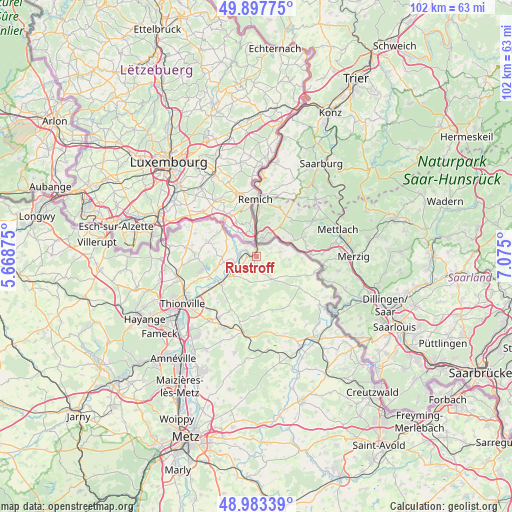
Rustroff GPS coordinates[2]
49° 26' 33.72" North, 6° 22' 18.732" East
| Map corner | latitude | longitude |
|---|---|---|
| Upper-left | 49.89775°, | 5.66875° |
| Center: | 49.4427°, | 6.37187° |
| Lower-right: | 48.98339°, | 7.075° |
| Map W x H: | 101.7×101.7 km | = 63.2×63.2mi |
| max Lat: | 51.07786° ⇑11.5% North |
| Rustroff: | 49.4427° |
| min Lat: | ⇓88.5% South 41.3874° |
| min Long | Rustroff | max Long |
| -5.08615° | 6.37187° | 9.52242° |
| W 90.9%⇐ | ⇒9.1% E |
Elevation
Elevation of Rustroff is 227 m = 745 ft, and this is 33.3 m = 109 ft above average elevation for this country.
| Max E: |
2333 m = 7654 ft | 28.4% |
| Rustroff | 227 m 745 ft | |
| Avg. | 193.7 m = 635 ft | |
Min E: |
-1 m = -3 ft | 71.6% |
See also: France elevation on elevation.city.
Geographical zone
Rustroff is located in North temperate zone (between Tropic of Cancer and the Arctic Circle). Distance of this North polar circle is 1903.7 km =1182.9 mi to North.| Distance of | km | miles | from Rustroff |
|---|---|---|---|
| North Pole | 4509.5 | 2802.1 | to North |
| Arctic Circle | 1903.7 | 1182.9 | to North |
| Tropic Cancer | 2891.6 | 1796.8 | to South |
| Equator | 5497.5 | 3416 | to South |


Nearby cities:
15 places around Rustroff: (largest is in red/bold)
• Apach
2 km =1.2 mi,  4°
4°
• Basse-Ham
11.3 km =7 mi,  236°
236°
• Cattenom
10.2 km =6.3 mi,  246°
246°
• Elzange
10.9 km =6.8 mi,  214°
214°
• Gavisse
6.3 km =3.9 mi,  259°
259°
• Hunting
4.5 km =2.8 mi,  227°
227°
• Kœnigsmacker
8 km =5 mi, 233°
• Malling
5.8 km =3.6 mi, 248°
• Oudrenne
7.7 km =4.8 mi,  204°
204°
• Puttelange-lès-Thionville
9.1 km =5.7 mi,  301°
301°
• Rettel
3 km =1.9 mi,  268°
268°
• Rodemack
10.3 km =6.4 mi,  287°
287°
• Sierck-les-Bains
1.1 km =0.7 mi, 249°
• Veckring
11.7 km =7.3 mi,  178°
178°
• Waldwisse
11.8 km =7.3 mi,  105°
105°
Sources, notices
• [Note1] Compared only with cities in France existing in our database
• [Src1] Map data: © OpenStreetMap contributors (CC-BY-SA)
• [Src2] Other city data from geonames.org with taken over terms of usage.
• [Src3] Geographical zone / Annual Mean Temperature by Robert A. Rohde @ Wikipedia
