Malling geodata
Malling (Grand Est) is a populated place; located in France in Europe/Paris (GMT+2) time zone. With population of 531 people, there are 14589 cities with bigger population in this country. Compared to other cities in France, 88.3% of cities are located further ↓South; 90.1% of cities are located further ←West and 58.9% of cities have lower elevation than Malling. Note1
Administrative division(s):
- Level 1: Grand Est
- Level 2: Moselle
- Level 3: Arrondissement de Thionville
- Level 4: Malling


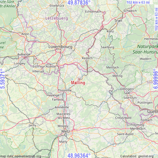
Malling GPS coordinates[2]
49° 25' 23.268" North, 6° 17' 48.588" East
| Map corner | latitude | longitude |
|---|---|---|
| Upper-left | 49.87836°, | 5.59371° |
| Center: | 49.42313°, | 6.29683° |
| Lower-right: | 48.96364°, | 6.99996° |
| Map W x H: | 101.7×101.7 km | = 63.2×63.2mi |
| max Lat: | 51.07786° ⇑11.7% North |
| Malling: | 49.42313° |
| min Lat: | ⇓88.3% South 41.3874° |
| min Long | Malling | max Long |
| -5.08615° | 6.29683° | 9.52242° |
| W 90.1%⇐ | ⇒9.9% E |
Elevation
Elevation of Malling is 165 m = 541 ft, and this is 28.7 m = 94 ft below average elevation for this country.
| Max E: |
2333 m = 7654 ft | 41.1% |
| Avg. | 193.7 m = 635 ft | |
| Malling | 165 m = 541 ft | |
Min E: |
-1 m = -3 ft | 58.9% |
See also: France elevation on elevation.city.
Geographical zone
Malling is located in North temperate zone (between Tropic of Cancer and the Arctic Circle). Distance of this North polar circle is 1905.8 km =1184.2 mi to North.| Distance of | km | miles | from Malling |
|---|---|---|---|
| North Pole | 4511.7 | 2803.4 | to North |
| Arctic Circle | 1905.8 | 1184.2 | to North |
| Tropic Cancer | 2889.4 | 1795.4 | to South |
| Equator | 5495.3 | 3414.6 | to South |


Nearby cities:
15 places around Malling: (largest is in red/bold)
• Apach
7 km =4.3 mi,  53°
53°
• Basse-Ham
5.7 km =3.5 mi,  224°
224°
• Boust
7.7 km =4.8 mi,  280°
280°
• Cattenom
4.3 km =2.7 mi,  244°
244°
• Elzange
6.8 km =4.2 mi,  186°
186°
• Gavisse
1.3 km =0.8 mi,  324°
324°
• Hunting
2.3 km =1.4 mi,  113°
113°
• Kuntzig
9.5 km =5.9 mi,  207°
207°
• Kœnigsmacker
2.8 km =1.7 mi,  200°
200°
• Oudrenne
5.3 km =3.3 mi,  155°
155°
• Puttelange-lès-Thionville
7.3 km =4.5 mi,  341°
341°
• Rettel
3.2 km =2 mi, 49°
• Rodemack
6.8 km =4.2 mi, 319°
• Rustroff
5.8 km =3.6 mi,  68°
68°
• Sierck-les-Bains
4.8 km =3 mi, 67°
Sources, notices
• [Note1] Compared only with cities in France existing in our database
• [Src1] Map data: © OpenStreetMap contributors (CC-BY-SA)
• [Src2] Other city data from geonames.org with taken over terms of usage.
• [Src3] Geographical zone / Annual Mean Temperature by Robert A. Rohde @ Wikipedia
