Hunting geodata
Hunting (Grand Est) is a populated place; located in France in Europe/Paris (GMT+2) time zone. With population of 584 people, there are 13570 cities with bigger population in this country. Compared to other cities in France, 88.2% of cities are located further ↓South; 90.4% of cities are located further ←West and 63.6% of cities have lower elevation than Hunting. Note1
Administrative division(s):
- Level 1: Grand Est
- Level 2: Moselle
- Level 3: Arrondissement de Thionville
- Level 4: Hunting


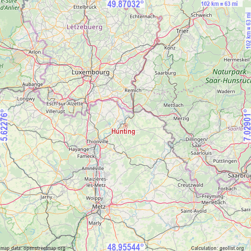
Hunting GPS coordinates[2]
49° 24' 54.036" North, 6° 19' 33.168" East
| Map corner | latitude | longitude |
|---|---|---|
| Upper-left | 49.87032°, | 5.62276° |
| Center: | 49.41501°, | 6.32588° |
| Lower-right: | 48.95544°, | 7.02901° |
| Map W x H: | 101.7×101.7 km | = 63.2×63.2mi |
| max Lat: | 51.07786° ⇑11.8% North |
| Hunting: | 49.41501° |
| min Lat: | ⇓88.2% South 41.3874° |
| min Long | Hunting | max Long |
| -5.08615° | 6.32588° | 9.52242° |
| W 90.4%⇐ | ⇒9.6% E |
Elevation
Elevation of Hunting is 187 m = 614 ft, and this is 6.7 m = 22 ft below average elevation for this country.
| Max E: |
2333 m = 7654 ft | 36.4% |
| Avg. | 193.7 m = 635 ft | |
| Hunting | 187 m = 614 ft | |
Min E: |
-1 m = -3 ft | 63.6% |
See also: France elevation on elevation.city.
Geographical zone
Hunting is located in North temperate zone (between Tropic of Cancer and the Arctic Circle). Distance of this North polar circle is 1906.7 km =1184.8 mi to North.| Distance of | km | miles | from Hunting |
|---|---|---|---|
| North Pole | 4512.6 | 2804 | to North |
| Arctic Circle | 1906.7 | 1184.8 | to North |
| Tropic Cancer | 2888.5 | 1794.8 | to South |
| Equator | 5494.4 | 3414.1 | to South |


Nearby cities:
15 places around Hunting: (largest is in red/bold)
• Apach
6.2 km =3.9 mi,  34°
34°
• Basse-Ham
6.9 km =4.3 mi,  242°
242°
• Cattenom
6.1 km =3.8 mi,  260°
260°
• Elzange
6.5 km =4 mi,  206°
206°
• Gavisse
3.4 km =2.1 mi,  304°
304°
• Kuntzig
9.9 km =6.2 mi,  220°
220°
• Kœnigsmacker
3.5 km =2.2 mi, 241°
• Malling
2.3 km =1.4 mi,  293°
293°
• Oudrenne
4 km =2.5 mi,  178°
178°
• Puttelange-lès-Thionville
9 km =5.6 mi,  330°
330°
• Rettel
3 km =1.9 mi,  6°
6°
• Rodemack
8.9 km =5.5 mi,  313°
313°
• Rustroff
4.5 km =2.8 mi,  47°
47°
• Sierck-les-Bains
3.6 km =2.2 mi,  40°
40°
• Veckring
9.4 km =5.8 mi,  156°
156°
Sources, notices
• [Note1] Compared only with cities in France existing in our database
• [Src1] Map data: © OpenStreetMap contributors (CC-BY-SA)
• [Src2] Other city data from geonames.org with taken over terms of usage.
• [Src3] Geographical zone / Annual Mean Temperature by Robert A. Rohde @ Wikipedia
