Cattenom geodata
Cattenom (Grand Est) is a populated place; located in France in Europe/Paris (GMT+2) time zone. With population of 2,417 people, there are 4001 cities with bigger population in this country. Compared to other cities in France, 88% of cities are located further ↓South; 89.7% of cities are located further ←West and 55% of cities have lower elevation than Cattenom. Note1
Administrative division(s):
- Level 1: Grand Est
- Level 2: Moselle
- Level 3: Arrondissement de Thionville
- Level 4: Cattenom


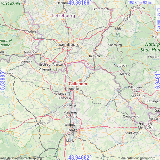
Cattenom GPS coordinates[2]
49° 24' 22.572" North, 6° 14' 34.692" East
| Map corner | latitude | longitude |
|---|---|---|
| Upper-left | 49.86166°, | 5.53985° |
| Center: | 49.40627°, | 6.24297° |
| Lower-right: | 48.94662°, | 6.9461° |
| Map W x H: | 101.7×101.7 km | = 63.2×63.2mi |
| max Lat: | 51.07786° ⇑12% North |
| Cattenom: | 49.40627° |
| min Lat: | ⇓88% South 41.3874° |
| min Long | Cattenom | max Long |
| -5.08615° | 6.24297° | 9.52242° |
| W 89.7%⇐ | ⇒10.3% E |
Elevation
Elevation of Cattenom is 150 m = 492 ft, and this is 43.7 m = 143 ft below average elevation for this country.
| Max E: |
2333 m = 7654 ft | 45% |
| Avg. | 193.7 m = 635 ft | |
| Cattenom | 150 m = 492 ft | |
Min E: |
-1 m = -3 ft | 55% |
See also: France elevation on elevation.city.
Geographical zone
Cattenom is located in North temperate zone (between Tropic of Cancer and the Arctic Circle). Distance of this North polar circle is 1907.7 km =1185.4 mi to North.| Distance of | km | miles | from Cattenom |
|---|---|---|---|
| North Pole | 4513.6 | 2804.6 | to North |
| Arctic Circle | 1907.7 | 1185.4 | to North |
| Tropic Cancer | 2887.5 | 1794.2 | to South |
| Equator | 5493.5 | 3413.5 | to South |


Nearby cities:
15 places around Cattenom: (largest is in red/bold)
• Basse-Ham
2.2 km =1.4 mi,  182°
182°
• Boust
4.9 km =3 mi,  311°
311°
• Elzange
5.8 km =3.6 mi,  147°
147°
• Gavisse
4.3 km =2.7 mi,  47°
47°
• Hettange-Grande
6.6 km =4.1 mi,  270°
270°
• Hunting
6.1 km =3.8 mi,  80°
80°
• Kuntzig
6.6 km =4.1 mi, 183°
• Kœnigsmacker
3 km =1.9 mi,  103°
103°
• Malling
4.3 km =2.7 mi,  64°
64°
• Manom
5.8 km =3.6 mi,  227°
227°
• Oudrenne
6.8 km =4.2 mi,  116°
116°
• Rettel
7.5 km =4.7 mi, 57°
• Rodemack
7.1 km =4.4 mi,  355°
355°
• Roussy-le-Village
7.5 km =4.7 mi,  318°
318°
• Yutz
6.7 km =4.2 mi,  212°
212°
Sources, notices
• [Note1] Compared only with cities in France existing in our database
• [Src1] Map data: © OpenStreetMap contributors (CC-BY-SA)
• [Src2] Other city data from geonames.org with taken over terms of usage.
• [Src3] Geographical zone / Annual Mean Temperature by Robert A. Rohde @ Wikipedia
