Rodemack geodata
Rodemack (Grand Est) is a populated place; located in France in Europe/Paris (GMT+2) time zone. With population of 837 people, there are 10216 cities with bigger population in this country. Compared to other cities in France, 88.8% of cities are located further ↓South; 89.7% of cities are located further ←West and 64.9% of cities have lower elevation than Rodemack. Note1
Administrative division(s):
- Level 1: Grand Est
- Level 2: Moselle
- Level 3: Arrondissement de Thionville
- Level 4: Rodemack


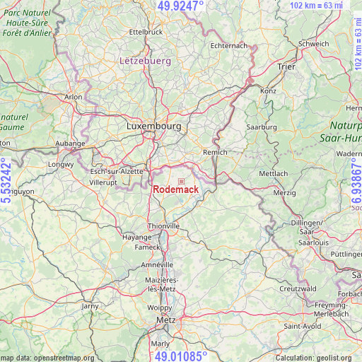
Rodemack GPS coordinates[2]
49° 28' 11.676" North, 6° 14' 7.98" East
| Map corner | latitude | longitude |
|---|---|---|
| Upper-left | 49.9247°, | 5.53242° |
| Center: | 49.46991°, | 6.23555° |
| Lower-right: | 49.01085°, | 6.93867° |
| Map W x H: | 101.6×101.6 km | = 63.1×63.1mi |
| max Lat: | 51.07786° ⇑11.2% North |
| Rodemack: | 49.46991° |
| min Lat: | ⇓88.8% South 41.3874° |
| min Long | Rodemack | max Long |
| -5.08615° | 6.23555° | 9.52242° |
| W 89.7%⇐ | ⇒10.3% E |
Elevation
Elevation of Rodemack is 193 m = 633 ft, and this is 0.69999999999999 m = 2 ft below average elevation for this country.
| Max E: |
2333 m = 7654 ft | 35.1% |
| Avg. | 193.7 m = 635 ft | |
| Rodemack | 193 m = 633 ft | |
Min E: |
-1 m = -3 ft | 64.9% |
See also: France elevation on elevation.city.
Geographical zone
Rodemack is located in North temperate zone (between Tropic of Cancer and the Arctic Circle). Distance of this North polar circle is 1900.6 km =1181 mi to North.| Distance of | km | miles | from Rodemack |
|---|---|---|---|
| North Pole | 4506.5 | 2800.2 | to North |
| Arctic Circle | 1900.6 | 1181 | to North |
| Tropic Cancer | 2894.6 | 1798.6 | to South |
| Equator | 5500.5 | 3417.9 | to South |


Nearby cities:
15 places around Rodemack: (largest is in red/bold)
• Apach
10.1 km =6.3 mi,  95°
95°
• Basse-Ham
9.3 km =5.8 mi,  177°
177°
• Boust
5 km =3.1 mi,  219°
219°
• Cattenom
7.1 km =4.4 mi, 175°
• Gavisse
5.6 km =3.5 mi,  138°
138°
• Hettange-Grande
9.3 km =5.8 mi, 220°
• Hunting
8.9 km =5.5 mi,  133°
133°
• Kanfen
9.8 km =6.1 mi,  249°
249°
• Kœnigsmacker
8.5 km =5.3 mi,  156°
156°
• Malling
6.8 km =4.2 mi, 139°
• Puttelange-lès-Thionville
2.7 km =1.7 mi,  51°
51°
• Rettel
7.5 km =4.7 mi,  114°
114°
• Roussy-le-Village
4.7 km =2.9 mi, 252°
• Sierck-les-Bains
9.5 km =5.9 mi, 110°
• Zoufftgen
7.4 km =4.6 mi,  262°
262°
Sources, notices
• [Note1] Compared only with cities in France existing in our database
• [Src1] Map data: © OpenStreetMap contributors (CC-BY-SA)
• [Src2] Other city data from geonames.org with taken over terms of usage.
• [Src3] Geographical zone / Annual Mean Temperature by Robert A. Rohde @ Wikipedia
