Ranchicourt geodata
Ranchicourt (Hauts-de-France) is a populated place; located in France in Europe/Paris (GMT+2) time zone. With population of 1,091 people, there are 8187 cities with bigger population in this country. Compared to other cities in France, 96.8% of cities are located further ↓South; 51.5% of cities are located further ←West and 71.9% of cities have higher elevation than Ranchicourt. Note1
Administrative division(s):
- Level 1: Hauts-de-France
- Level 2: Pas-de-Calais
- Level 3: Arrondissement de Béthune
- Level 4: Rebreuve-Ranchicourt


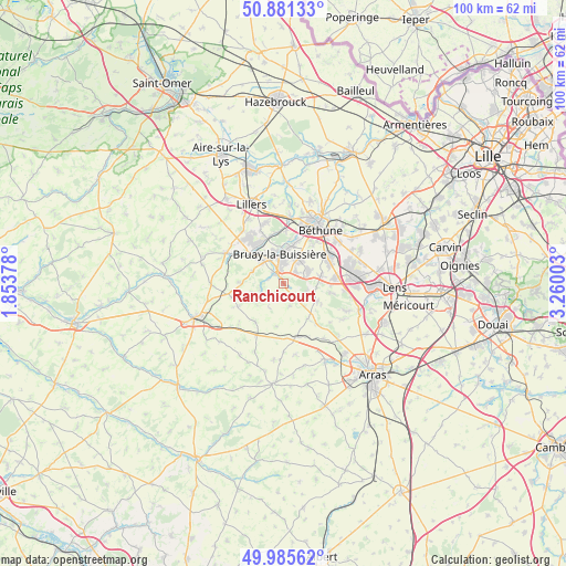
Ranchicourt GPS coordinates[2]
50° 26' 8.124" North, 2° 33' 24.84" East
| Map corner | latitude | longitude |
|---|---|---|
| Upper-left | 50.88133°, | 1.85378° |
| Center: | 50.43559°, | 2.5569° |
| Lower-right: | 49.98562°, | 3.26003° |
| Map W x H: | 99.6×99.6 km | = 61.9×61.9mi |
| max Lat: | 51.07786° ⇑3.2% North |
| Ranchicourt: | 50.43559° |
| min Lat: | ⇓96.8% South 41.3874° |
| min Long | Ranchicourt | max Long |
| -5.08615° | 2.5569° | 9.52242° |
| W 51.5%⇐ | ⇒48.5% E |
Elevation
Elevation of Ranchicourt is 74 m = 243 ft, and this is 119.7 m = 393 ft below average elevation for this country.
| Max E: |
2333 m = 7654 ft | 71.9% |
| Avg. | 193.7 m = 635 ft | |
| Ranchicourt | 74 m = 243 ft | |
Min E: |
-1 m = -3 ft | 28.1% |
See also: France elevation on elevation.city.
Geographical zone
Ranchicourt is located in North temperate zone (between Tropic of Cancer and the Arctic Circle). Distance of this North polar circle is 1793.3 km =1114.3 mi to North.| Distance of | km | miles | from Ranchicourt |
|---|---|---|---|
| North Pole | 4399.2 | 2733.5 | to North |
| Arctic Circle | 1793.3 | 1114.3 | to North |
| Tropic Cancer | 3002 | 1865.4 | to South |
| Equator | 5607.9 | 3484.6 | to South |


Nearby cities:
15 places around Ranchicourt: (largest is in red/bold)
• Barlin
4.8 km =3 mi,  67°
67°
• Bruay-la-Buissière
5.3 km =3.3 mi,  354°
354°
• Divion
5.4 km =3.4 mi,  317°
317°
• Diéval
7.6 km =4.7 mi,  269°
269°
• Fresnicourt-le-Dolmen
3.6 km =2.2 mi,  121°
121°
• Haillicourt
4.6 km =2.9 mi,  15°
15°
• Hersin-Coupigny
6.7 km =4.2 mi,  78°
78°
• Houchin
6.8 km =4.2 mi,  40°
40°
• Houdain
2.1 km =1.3 mi, 320°
• La Comté
4.7 km =2.9 mi,  256°
256°
• Magnicourt-en-Comte
5.6 km =3.5 mi,  225°
225°
• Maisnil-lès-Ruitz
3.1 km =1.9 mi,  49°
49°
• Ourton
5.8 km =3.6 mi,  293°
293°
• Ruitz
4.1 km =2.5 mi,  33°
33°
• Servins
6.1 km =3.8 mi, 117°
Sources, notices
• [Note1] Compared only with cities in France existing in our database
• [Src1] Map data: © OpenStreetMap contributors (CC-BY-SA)
• [Src2] Other city data from geonames.org with taken over terms of usage.
• [Src3] Geographical zone / Annual Mean Temperature by Robert A. Rohde @ Wikipedia
