Sauveterre-de-Guyenne geodata
Sauveterre-de-Guyenne (Nouvelle-Aquitaine) is a populated place; located in France in Europe/Paris (GMT+2) time zone. With population of 1,722 people, there are 5468 cities with bigger population in this country. Compared to other cities in France, 82.1% of cities are located further ↑North; 78.8% of cities are located further →East and 69.7% of cities have higher elevation than Sauveterre-de-Guyenne. Note1
Administrative division(s):
- Level 1: Nouvelle-Aquitaine
- Level 2: Gironde
- Level 3: Arrondissement de Langon
- Level 4: Sauveterre-de-Guyenne
Current local time in Sauveterre-de-Guyenne:
03:17 PM, SaturdayDifference from your time zone: hours


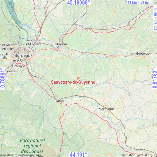
Sauveterre-de-Guyenne GPS coordinates[2]
44° 41' 34.8" North, 0° 5' 7.764" West
| Map corner | latitude | longitude |
|---|---|---|
| Upper-left | 45.19068°, | -0.78861° |
| Center: | 44.693°, | -0.08549° |
| Lower-right: | 44.191°, | 0.61763° |
| Map W x H: | 111.2×111.2 km | = 69.1×69.1mi |
| max Lat: | 51.07786° ⇑82.1% North |
| Sauveterre-de-Guyenne: | 44.693° |
| min Lat: | ⇓17.9% South 41.3874° |
| min Long | Sauveterre-de-G | max Long |
| -5.08615° | -0.08549° | 9.52242° |
| W 21.2%⇐ | ⇒78.8% E |
Elevation
Elevation of Sauveterre-de-Guyenne is 79 m = 259 ft, and this is 114.7 m = 376 ft below average elevation for this country.
| Max E: |
2333 m = 7654 ft | 69.7% |
| Avg. | 193.7 m = 635 ft | |
| Sauveterre-de-Guyenne | 79 m = 259 ft | |
Min E: |
-1 m = -3 ft | 30.3% |
See also: France elevation on elevation.city.
Geographical zone
Sauveterre-de-Guyenne is located in North temperate zone (between Tropic of Cancer and the Arctic Circle). Distance of this Northern Tropic circle is 2363.5 km =1468.6 mi to South.| Distance of | km | miles | from Sauveterre-de-Guyenne |
|---|---|---|---|
| North Pole | 5037.7 | 3130.3 | to North |
| Arctic Circle | 2431.8 | 1511 | to North |
| Tropic Cancer | 2363.5 | 1468.6 | to South |
| Equator | 4969.4 | 3087.8 | to South |


Nearby cities:
15 places around Sauveterre-de-Guyenne: (largest is in red/bold)
• Blasimon
6.3 km =3.9 mi,  8°
8°
• Caudrot
13.8 km =8.6 mi,  199°
199°
• Fontet
15.5 km =9.6 mi,  163°
163°
• Frontenac
7.9 km =4.9 mi,  309°
309°
• Gironde-sur-Dropt
12.2 km =7.6 mi,  179°
179°
• La Réole
12.9 km =8 mi, 162°
• Monségur
14 km =8.7 mi,  109°
109°
• Morizès
9 km =5.6 mi, 182°
• Naujan-et-Postiac
13.1 km =8.1 mi,  324°
324°
• Pellegrue
13.9 km =8.6 mi,  66°
66°
• Rauzan
10 km =6.2 mi,  341°
341°
• Ruch
9.9 km =6.2 mi,  21°
21°
• Saint-Martin-de-Sescas
14.4 km =8.9 mi, 204°
• Saint-Pey-de-Castets
13.2 km =8.2 mi, 6°
• Targon
14.8 km =9.2 mi,  288°
288°
Sources, notices
• [Note1] Compared only with cities in France existing in our database
• [Src1] Map data: © OpenStreetMap contributors (CC-BY-SA)
• [Src2] Other city data from geonames.org with taken over terms of usage.
• [Src3] Geographical zone / Annual Mean Temperature by Robert A. Rohde @ Wikipedia
