Pellegrue geodata
Pellegrue (Nouvelle-Aquitaine) is a populated place; located in France in Europe/Paris (GMT+2) time zone. With population of 1,075 people, there are 8295 cities with bigger population in this country. Compared to other cities in France, 81.8% of cities are located further ↑North; 77.5% of cities are located further →East and 59.4% of cities have higher elevation than Pellegrue. Note1
Administrative division(s):
- Level 1: Nouvelle-Aquitaine
- Level 2: Gironde
- Level 3: Arrondissement de Langon
- Level 4: Pellegrue


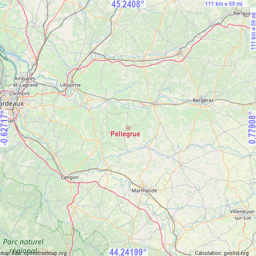
Pellegrue GPS coordinates[2]
44° 44' 36.78" North, 0° 4' 33.42" East
| Map corner | latitude | longitude |
|---|---|---|
| Upper-left | 45.2408°, | -0.62717° |
| Center: | 44.74355°, | 0.07595° |
| Lower-right: | 44.24199°, | 0.77908° |
| Map W x H: | 111.1×111.1 km | = 69×69mi |
| max Lat: | 51.07786° ⇑81.8% North |
| Pellegrue: | 44.74355° |
| min Lat: | ⇓18.2% South 41.3874° |
| min Long | Pellegrue | max Long |
| -5.08615° | 0.07595° | 9.52242° |
| W 22.5%⇐ | ⇒77.5% E |
Elevation
Elevation of Pellegrue is 104 m = 341 ft, and this is 89.7 m = 294 ft below average elevation for this country.
| Max E: |
2333 m = 7654 ft | 59.4% |
| Avg. | 193.7 m = 635 ft | |
| Pellegrue | 104 m = 341 ft | |
Min E: |
-1 m = -3 ft | 40.6% |
See also: France elevation on elevation.city.
Geographical zone
Pellegrue is located in North temperate zone (between Tropic of Cancer and the Arctic Circle). Distance of this Northern Tropic circle is 2369.1 km =1472.1 mi to South.| Distance of | km | miles | from Pellegrue |
|---|---|---|---|
| North Pole | 5032 | 3126.7 | to North |
| Arctic Circle | 2426.2 | 1507.6 | to North |
| Tropic Cancer | 2369.1 | 1472.1 | to South |
| Equator | 4975 | 3091.3 | to South |


Nearby cities:
15 places around Pellegrue: (largest is in red/bold)
• Blasimon
11.9 km =7.4 mi,  272°
272°
• Duras
11.3 km =7 mi,  131°
131°
• Flaujagues
10.2 km =6.3 mi,  348°
348°
• Gensac
6.9 km =4.3 mi,  358°
358°
• Lamothe-Montravel
12.3 km =7.6 mi,  344°
344°
• Monségur
10.4 km =6.5 mi,  178°
178°
• Montcaret
11.9 km =7.4 mi, 356°
• Mouliets-et-Villemartin
12.4 km =7.7 mi,  323°
323°
• Port-Sainte-Foy-et-Ponchapt
14 km =8.7 mi,  44°
44°
• Ruch
9.8 km =6.1 mi,  291°
291°
• Saint-Antoine-de-Breuilh
12.3 km =7.6 mi, 35°
• Saint-Pey-de-Castets
13.6 km =8.5 mi,  303°
303°
• Saint-Seurin-de-Prats
10 km =6.2 mi,  3°
3°
• Sauveterre-de-Guyenne
13.9 km =8.6 mi,  246°
246°
• Vélines
12.3 km =7.6 mi,  15°
15°
Sources, notices
• [Note1] Compared only with cities in France existing in our database
• [Src1] Map data: © OpenStreetMap contributors (CC-BY-SA)
• [Src2] Other city data from geonames.org with taken over terms of usage.
• [Src3] Geographical zone / Annual Mean Temperature by Robert A. Rohde @ Wikipedia
