Roye geodata
Roye (Hauts-de-France) is a populated place; located in France in Europe/Paris (GMT+2) time zone. With population of 6,655 people, there are 1485 cities with bigger population in this country. Compared to other cities in France, 91.5% of cities are located further ↓South; 54.8% of cities are located further ←West and 66% of cities have higher elevation than Roye. Note1
Administrative division(s):
- Level 1: Hauts-de-France
- Level 2: Somme
- Level 3: Arrondissement de Montdidier
- Level 4: Roye


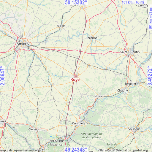
Roye GPS coordinates[2]
49° 42' 1.368" North, 2° 47' 22.524" East
| Map corner | latitude | longitude |
|---|---|---|
| Upper-left | 50.15302°, | 2.08647° |
| Center: | 49.70038°, | 2.78959° |
| Lower-right: | 49.24348°, | 3.49272° |
| Map W x H: | 101.1×101.1 km | = 62.8×62.8mi |
| max Lat: | 51.07786° ⇑8.5% North |
| Roye: | 49.70038° |
| min Lat: | ⇓91.5% South 41.3874° |
| min Long | Roye | max Long |
| -5.08615° | 2.78959° | 9.52242° |
| W 54.8%⇐ | ⇒45.2% E |
Elevation
Elevation of Roye is 87 m = 285 ft, and this is 106.7 m = 350 ft below average elevation for this country.
| Max E: |
2333 m = 7654 ft | 66% |
| Avg. | 193.7 m = 635 ft | |
| Roye | 87 m = 285 ft | |
Min E: |
-1 m = -3 ft | 34% |
See also: France elevation on elevation.city.
Geographical zone
Roye is located in North temperate zone (between Tropic of Cancer and the Arctic Circle). Distance of this North polar circle is 1875 km =1165.1 mi to North.| Distance of | km | miles | from Roye |
|---|---|---|---|
| North Pole | 4480.9 | 2784.3 | to North |
| Arctic Circle | 1875 | 1165.1 | to North |
| Tropic Cancer | 2920.2 | 1814.5 | to South |
| Equator | 5526.2 | 3433.8 | to South |


Nearby cities:
15 places around Roye: (largest is in red/bold)
• Arvillers
11.4 km =7.1 mi,  295°
295°
• Beaulieu-les-Fontaines
9.9 km =6.2 mi,  116°
116°
• Beuvraignes
6.2 km =3.9 mi,  193°
193°
• Chaulnes
13 km =8.1 mi,  3°
3°
• Conchy-les-Pots
11.8 km =7.3 mi,  203°
203°
• Ercheu
10.9 km =6.8 mi,  88°
88°
• Hangest-en-Santerre
14.4 km =8.9 mi,  293°
293°
• Hombleux
14.8 km =9.2 mi,  72°
72°
• Lassigny
13 km =8.1 mi,  162°
162°
• Le Quesnel
14.6 km =9.1 mi,  305°
305°
• Mesnil-Saint-Nicaise
12.8 km =8 mi,  47°
47°
• Méharicourt
11.6 km =7.2 mi,  339°
339°
• Nesle
10.9 km =6.8 mi, 53°
• Orvillers-Sorel
14.8 km =9.2 mi, 203°
• Rosières-en-Santerre
14.2 km =8.8 mi,  333°
333°
Sources, notices
• [Note1] Compared only with cities in France existing in our database
• [Src1] Map data: © OpenStreetMap contributors (CC-BY-SA)
• [Src2] Other city data from geonames.org with taken over terms of usage.
• [Src3] Geographical zone / Annual Mean Temperature by Robert A. Rohde @ Wikipedia
