Hangest-en-Santerre geodata
Hangest-en-Santerre (Hauts-de-France) is a populated place; located in France in Europe/Paris (GMT+2) time zone. With population of 954 people, there are 9174 cities with bigger population in this country. Compared to other cities in France, 92% of cities are located further ↓South; 52.2% of cities are located further ←West and 57.9% of cities have higher elevation than Hangest-en-Santerre. Note1
Administrative division(s):
- Level 1: Hauts-de-France
- Level 2: Somme
- Level 3: Arrondissement de Montdidier
- Level 4: Hangest-en-Santerre


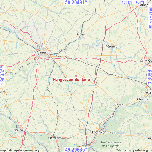
Hangest-en-Santerre GPS coordinates[2]
49° 45' 9.936" North, 2° 36' 23.292" East
| Map corner | latitude | longitude |
|---|---|---|
| Upper-left | 50.20491°, | 1.90335° |
| Center: | 49.75276°, | 2.60647° |
| Lower-right: | 49.29635°, | 3.3096° |
| Map W x H: | 101×101 km | = 62.8×62.8mi |
| max Lat: | 51.07786° ⇑8% North |
| Hangest-en-Santerre: | 49.75276° |
| min Lat: | ⇓92% South 41.3874° |
| min Long | Hangest-en-Sant | max Long |
| -5.08615° | 2.60647° | 9.52242° |
| W 52.2%⇐ | ⇒47.8% E |
Elevation
Elevation of Hangest-en-Santerre is 108 m = 354 ft, and this is 85.7 m = 281 ft below average elevation for this country.
| Max E: |
2333 m = 7654 ft | 57.9% |
| Avg. | 193.7 m = 635 ft | |
| Hangest-en-Santerre | 108 m = 354 ft | |
Min E: |
-1 m = -3 ft | 42.1% |
See also: France elevation on elevation.city.
Geographical zone
Hangest-en-Santerre is located in North temperate zone (between Tropic of Cancer and the Arctic Circle). Distance of this North polar circle is 1869.2 km =1161.5 mi to North.| Distance of | km | miles | from Hangest-en-Santerre |
|---|---|---|---|
| North Pole | 4475.1 | 2780.7 | to North |
| Arctic Circle | 1869.2 | 1161.5 | to North |
| Tropic Cancer | 2926.1 | 1818.2 | to South |
| Equator | 5532 | 3437.4 | to South |


Nearby cities:
15 places around Hangest-en-Santerre: (largest is in red/bold)
• Arvillers
3 km =1.9 mi,  105°
105°
• Caix
7.7 km =4.8 mi,  21°
21°
• Chaulnes
15.7 km =9.8 mi,  62°
62°
• Harbonnières
11.6 km =7.2 mi, 22°
• Le Plessier-Rozainvillers
3.8 km =2.4 mi,  267°
267°
• Le Quesnel
2.9 km =1.8 mi,  26°
26°
• Marcelcave
11.1 km =6.9 mi,  348°
348°
• Montdidier
11.9 km =7.4 mi,  192°
192°
• Moreuil
9.2 km =5.7 mi,  285°
285°
• Méharicourt
10.3 km =6.4 mi, 60°
• Mézières-en-Santerre
5.3 km =3.3 mi,  315°
315°
• Proyart
16.5 km =10.3 mi, 25°
• Rosières-en-Santerre
9.6 km =6 mi,  44°
44°
• Roye
14.4 km =8.9 mi, 113°
• Villers-Bretonneux
14.4 km =8.9 mi,  333°
333°
Sources, notices
• [Note1] Compared only with cities in France existing in our database
• [Src1] Map data: © OpenStreetMap contributors (CC-BY-SA)
• [Src2] Other city data from geonames.org with taken over terms of usage.
• [Src3] Geographical zone / Annual Mean Temperature by Robert A. Rohde @ Wikipedia
