Rosières-en-Santerre geodata
Rosières-en-Santerre (Hauts-de-France) is a populated place; located in France in Europe/Paris (GMT+2) time zone. With population of 3,000 people, there are 3252 cities with bigger population in this country. Compared to other cities in France, 92.3% of cities are located further ↓South; 53.5% of cities are located further ←West and 64.4% of cities have higher elevation than Rosières-en-Santerre. Note1
Administrative division(s):
- Level 1: Hauts-de-France
- Level 2: Somme
- Level 3: Arrondissement de Péronne
- Level 4: Rosières-en-Santerre


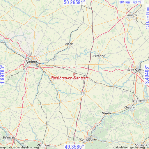
Rosières-en-Santerre GPS coordinates[2]
49° 48' 51.588" North, 2° 42' 3.42" East
| Map corner | latitude | longitude |
|---|---|---|
| Upper-left | 50.26591°, | 1.99783° |
| Center: | 49.81433°, | 2.70095° |
| Lower-right: | 49.3585°, | 3.40408° |
| Map W x H: | 100.9×100.9 km | = 62.7×62.7mi |
| max Lat: | 51.07786° ⇑7.7% North |
| Rosières-en-Santerre: | 49.81433° |
| min Lat: | ⇓92.3% South 41.3874° |
| min Long | Rosières-en-Sa | max Long |
| -5.08615° | 2.70095° | 9.52242° |
| W 53.5%⇐ | ⇒46.5% E |
Elevation
Elevation of Rosières-en-Santerre is 91 m = 299 ft, and this is 102.7 m = 337 ft below average elevation for this country.
| Max E: |
2333 m = 7654 ft | 64.4% |
| Avg. | 193.7 m = 635 ft | |
| Rosières-en-Santerre | 91 m = 299 ft | |
Min E: |
-1 m = -3 ft | 35.6% |
See also: France elevation on elevation.city.
Geographical zone
Rosières-en-Santerre is located in North temperate zone (between Tropic of Cancer and the Arctic Circle). Distance of this North polar circle is 1862.3 km =1157.2 mi to North.| Distance of | km | miles | from Rosières-en-Santerre |
|---|---|---|---|
| North Pole | 4468.2 | 2776.4 | to North |
| Arctic Circle | 1862.3 | 1157.2 | to North |
| Tropic Cancer | 2932.9 | 1822.4 | to South |
| Equator | 5538.8 | 3441.6 | to South |


Nearby cities:
15 places around Rosières-en-Santerre: (largest is in red/bold)
• Arvillers
8.6 km =5.3 mi,  207°
207°
• Becquincourt
13.5 km =8.4 mi,  37°
37°
• Bray-sur-Somme
14.1 km =8.8 mi,  5°
5°
• Caix
3.9 km =2.4 mi,  274°
274°
• Chaulnes
7.2 km =4.5 mi,  87°
87°
• Hangest-en-Santerre
9.6 km =6 mi,  224°
224°
• Harbonnières
4.6 km =2.9 mi,  329°
329°
• Le Plessier-Rozainvillers
12.7 km =7.9 mi,  236°
236°
• Le Quesnel
6.9 km =4.3 mi,  232°
232°
• Marcelcave
9.9 km =6.2 mi,  293°
293°
• Méharicourt
2.9 km =1.8 mi,  129°
129°
• Mézières-en-Santerre
10.9 km =6.8 mi,  253°
253°
• Proyart
8.1 km =5 mi,  2°
2°
• Roye
14.2 km =8.8 mi,  153°
153°
• Villers-Bretonneux
14.5 km =9 mi, 294°
Sources, notices
• [Note1] Compared only with cities in France existing in our database
• [Src1] Map data: © OpenStreetMap contributors (CC-BY-SA)
• [Src2] Other city data from geonames.org with taken over terms of usage.
• [Src3] Geographical zone / Annual Mean Temperature by Robert A. Rohde @ Wikipedia
