Proyart geodata
Proyart (Hauts-de-France) is a populated place; located in France in Europe/Paris (GMT+2) time zone. With population of 542 people, there are 14349 cities with bigger population in this country. Compared to other cities in France, 92.9% of cities are located further ↓South; 53.6% of cities are located further ←West and 72.3% of cities have higher elevation than Proyart. Note1
Administrative division(s):
- Level 1: Hauts-de-France
- Level 2: Somme
- Level 3: Arrondissement de Péronne
- Level 4: Proyart


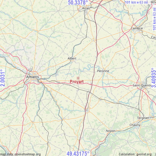
Proyart GPS coordinates[2]
49° 53' 12.84" North, 2° 42' 22.428" East
| Map corner | latitude | longitude |
|---|---|---|
| Upper-left | 50.3378°, | 2.0031° |
| Center: | 49.8869°, | 2.70623° |
| Lower-right: | 49.43175°, | 3.40935° |
| Map W x H: | 100.7×100.7 km | = 62.6×62.6mi |
| max Lat: | 51.07786° ⇑7.1% North |
| Proyart: | 49.8869° |
| min Lat: | ⇓92.9% South 41.3874° |
| min Long | Proyart | max Long |
| -5.08615° | 2.70623° | 9.52242° |
| W 53.6%⇐ | ⇒46.4% E |
Elevation
Elevation of Proyart is 73 m = 240 ft, and this is 120.7 m = 396 ft below average elevation for this country.
| Max E: |
2333 m = 7654 ft | 72.3% |
| Avg. | 193.7 m = 635 ft | |
| Proyart | 73 m = 240 ft | |
Min E: |
-1 m = -3 ft | 27.7% |
See also: France elevation on elevation.city.
Geographical zone
Proyart is located in North temperate zone (between Tropic of Cancer and the Arctic Circle). Distance of this North polar circle is 1854.3 km =1152.2 mi to North.| Distance of | km | miles | from Proyart |
|---|---|---|---|
| North Pole | 4460.2 | 2771.4 | to North |
| Arctic Circle | 1854.3 | 1152.2 | to North |
| Tropic Cancer | 2941 | 1827.5 | to South |
| Equator | 5546.9 | 3446.7 | to South |


Nearby cities:
15 places around Proyart: (largest is in red/bold)
• Albert
13.3 km =8.3 mi,  342°
342°
• Becquincourt
8.3 km =5.2 mi,  71°
71°
• Bray-sur-Somme
6.1 km =3.8 mi,  8°
8°
• Caix
8.8 km =5.5 mi,  208°
208°
• Chaulnes
10.3 km =6.4 mi,  138°
138°
• Cléry-sur-Somme
15.1 km =9.4 mi,  58°
58°
• Corbie
14.5 km =9 mi,  278°
278°
• Harbonnières
5 km =3.1 mi, 213°
• Le Quesnel
13.6 km =8.5 mi, 205°
• Marcelcave
10.3 km =6.4 mi,  246°
246°
• Méaulte
11 km =6.8 mi, 342°
• Méharicourt
10.1 km =6.3 mi,  169°
169°
• Ribemont-sur-Ancre
12.2 km =7.6 mi,  305°
305°
• Rosières-en-Santerre
8.1 km =5 mi,  182°
182°
• Villers-Bretonneux
13.7 km =8.5 mi,  261°
261°
Sources, notices
• [Note1] Compared only with cities in France existing in our database
• [Src1] Map data: © OpenStreetMap contributors (CC-BY-SA)
• [Src2] Other city data from geonames.org with taken over terms of usage.
• [Src3] Geographical zone / Annual Mean Temperature by Robert A. Rohde @ Wikipedia
