Puget-sur-Argens geodata
Puget-sur-Argens (Provence-Alpes-Côte d'Azur) is a populated place; located in France in Europe/Paris (GMT+2) time zone. With population of 6,943 people, there are 1424 cities with bigger population in this country. Compared to other cities in France, 93.6% of cities are located further ↑North; 92.9% of cities are located further ←West and 90.7% of cities have higher elevation than Puget-sur-Argens. Note1
Administrative division(s):
- Level 1: Provence-Alpes-Côte d'Azur
- Level 2: Var
- Level 3: Arrondissement de Draguignan
- Level 4: Puget-sur-Argens


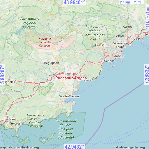
Puget-sur-Argens GPS coordinates[2]
43° 27' 20.736" North, 6° 41' 6.684" East
| Map corner | latitude | longitude |
|---|---|---|
| Upper-left | 43.96401°, | 5.98207° |
| Center: | 43.45576°, | 6.68519° |
| Lower-right: | 42.9432°, | 7.38832° |
| Map W x H: | 113.5×113.5 km | = 70.5×70.5mi |
| max Lat: | 51.07786° ⇑93.6% North |
| Puget-sur-Argens: | 43.45576° |
| min Lat: | ⇓6.4% South 41.3874° |
| min Long | Puget-sur-Argen | max Long |
| -5.08615° | 6.68519° | 9.52242° |
| W 92.9%⇐ | ⇒7.1% E |
Elevation
Elevation of Puget-sur-Argens is 28 m = 92 ft, and this is 165.7 m = 544 ft below average elevation for this country.
| Max E: |
2333 m = 7654 ft | 90.7% |
| Avg. | 193.7 m = 635 ft | |
| Puget-sur-Argens | 28 m = 92 ft | |
Min E: |
-1 m = -3 ft | 9.3% |
See also: France elevation on elevation.city.
Geographical zone
Puget-sur-Argens is located in North temperate zone (between Tropic of Cancer and the Arctic Circle). Distance of this Northern Tropic circle is 2225.9 km =1383.1 mi to South.| Distance of | km | miles | from Puget-sur-Argens |
|---|---|---|---|
| North Pole | 5175.2 | 3215.7 | to North |
| Arctic Circle | 2569.3 | 1596.5 | to North |
| Tropic Cancer | 2225.9 | 1383.1 | to South |
| Equator | 4831.8 | 3002.3 | to South |


Nearby cities:
15 places around Puget-sur-Argens: (largest is in red/bold)
• Bagnols-en-Forêt
9.2 km =5.7 mi,  6°
6°
• Callian
19.3 km =12 mi,  16°
16°
• Claviers
18.9 km =11.7 mi,  328°
328°
• Fayence
18.9 km =11.7 mi,  2°
2°
• Fréjus
4.8 km =3 mi,  121°
121°
• La Motte
12.8 km =8 mi,  289°
289°
• Le Muy
9.8 km =6.1 mi,  281°
281°
• Le Plan-de-la-Tour
17.5 km =10.9 mi,  218°
218°
• Les Arcs
16.7 km =10.4 mi,  272°
272°
• Montauroux
19.2 km =11.9 mi, 19°
• Roquebrune-sur-Argens
4.1 km =2.5 mi,  249°
249°
• Saint-Paul-en-Forêt
12.4 km =7.7 mi, 2°
• Saint-Raphaël
8 km =5 mi, 116°
• Sainte-Maxime
16.7 km =10.4 mi,  193°
193°
• Trans-en-Provence
16.9 km =10.5 mi, 288°
In other languages:
- In France: Puget-sur-Argens, Puget-sur Argens
- In Russian: Пюже-сюр-Аржан
- In Chinese: 阿尔冈河畔皮热
Sources, notices
• [Note1] Compared only with cities in France existing in our database
• [Src1] Map data: © OpenStreetMap contributors (CC-BY-SA)
• [Src2] Other city data from geonames.org with taken over terms of usage.
• [Src3] Geographical zone / Annual Mean Temperature by Robert A. Rohde @ Wikipedia
