Roissy-en-France geodata
Roissy-en-France (Île-de-France) is a populated place; located in France in Europe/Paris (GMT+2) time zone. With population of 2,651 people, there are 3673 cities with bigger population in this country. Compared to other cities in France, 79.8% of cities are located further ↓South; 50.9% of cities are located further ←West and 62.4% of cities have higher elevation than Roissy-en-France. Note1
Administrative division(s):
- Level 1: Île-de-France
- Level 2: Département du Val-d’Oise
- Level 3: Arrondissement de Sarcelles
- Level 4: Roissy-en-France


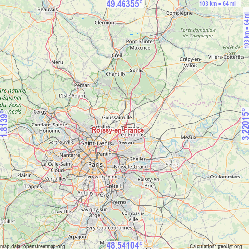
Roissy-en-France GPS coordinates[2]
49° 0' 15.948" North, 2° 31' 1.308" East
| Map corner | latitude | longitude |
|---|---|---|
| Upper-left | 49.46355°, | 1.8139° |
| Center: | 49.00443°, | 2.51703° |
| Lower-right: | 48.54104°, | 3.22015° |
| Map W x H: | 102.6×102.6 km | = 63.8×63.8mi |
| max Lat: | 51.07786° ⇑20.2% North |
| Roissy-en-France: | 49.00443° |
| min Lat: | ⇓79.8% South 41.3874° |
| min Long | Roissy-en-Franc | max Long |
| -5.08615° | 2.51703° | 9.52242° |
| W 50.9%⇐ | ⇒49.1% E |
Elevation
Elevation of Roissy-en-France is 96 m = 315 ft, and this is 97.7 m = 321 ft below average elevation for this country.
| Max E: |
2333 m = 7654 ft | 62.4% |
| Avg. | 193.7 m = 635 ft | |
| Roissy-en-France | 96 m = 315 ft | |
Min E: |
-1 m = -3 ft | 37.6% |
See also: France elevation on elevation.city.
Geographical zone
Roissy-en-France is located in North temperate zone (between Tropic of Cancer and the Arctic Circle). Distance of this North polar circle is 1952.4 km =1213.2 mi to North.| Distance of | km | miles | from Roissy-en-France |
|---|---|---|---|
| North Pole | 4558.3 | 2832.4 | to North |
| Arctic Circle | 1952.4 | 1213.2 | to North |
| Tropic Cancer | 2842.9 | 1766.5 | to South |
| Equator | 5448.8 | 3385.7 | to South |


Nearby cities:
15 places around Roissy-en-France: (largest is in red/bold)
• Arnouville
7.7 km =4.8 mi,  252°
252°
• Aulnay-sous-Bois
7.6 km =4.7 mi,  192°
192°
• Bonneuil-en-France
7.1 km =4.4 mi,  241°
241°
• Fontenay-en-Parisis
7.3 km =4.5 mi,  318°
318°
• Gonesse
5.3 km =3.3 mi, 248°
• Goussainville
3.9 km =2.4 mi,  285°
285°
• Le Mesnil-Amelot
5.8 km =3.6 mi,  75°
75°
• Le Thillay
3.3 km =2.1 mi,  274°
274°
• Louvres
4.6 km =2.9 mi,  348°
348°
• Mitry-Mory
7.6 km =4.7 mi,  107°
107°
• Puiseux-en-France
5.8 km =3.6 mi, 347°
• Sevran
6.7 km =4.2 mi,  173°
173°
• Tremblay-en-France
7.2 km =4.5 mi,  148°
148°
• Villepinte
4.8 km =3 mi, 166°
• Villeron
6.2 km =3.9 mi,  17°
17°
Sources, notices
• [Note1] Compared only with cities in France existing in our database
• [Src1] Map data: © OpenStreetMap contributors (CC-BY-SA)
• [Src2] Other city data from geonames.org with taken over terms of usage.
• [Src3] Geographical zone / Annual Mean Temperature by Robert A. Rohde @ Wikipedia
