Gonesse geodata
Gonesse (Île-de-France) is a populated place; located in France in Europe/Paris (GMT+2) time zone. With population of 26,758 people, there are 318 cities with bigger population in this country. Compared to other cities in France, 79.4% of cities are located further ↓South; 50.2% of cities are located further →East and 81.8% of cities have higher elevation than Gonesse. Note1
Administrative division(s):
- Level 1: Île-de-France
- Level 2: Département du Val-d’Oise
- Level 3: Arrondissement de Sarcelles
- Level 4: Gonesse


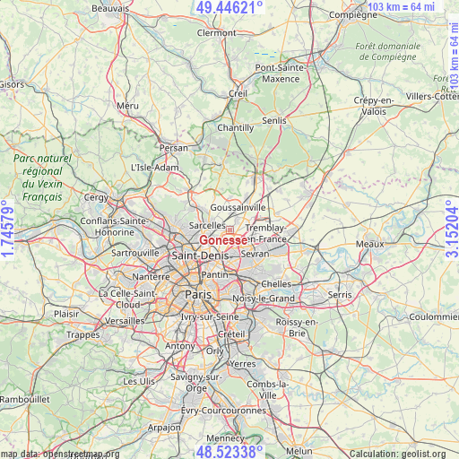
Gonesse GPS coordinates[2]
48° 59' 12.948" North, 2° 26' 56.112" East
| Map corner | latitude | longitude |
|---|---|---|
| Upper-left | 49.44621°, | 1.74579° |
| Center: | 48.98693°, | 2.44892° |
| Lower-right: | 48.52338°, | 3.15204° |
| Map W x H: | 102.6×102.6 km | = 63.8×63.8mi |
| max Lat: | 51.07786° ⇑20.6% North |
| Gonesse: | 48.98693° |
| min Lat: | ⇓79.4% South 41.3874° |
| min Long | Gonesse | max Long |
| -5.08615° | 2.44892° | 9.52242° |
| W 49.8%⇐ | ⇒50.2% E |
Elevation
Elevation of Gonesse is 50 m = 164 ft, and this is 143.7 m = 471 ft below average elevation for this country.
| Max E: |
2333 m = 7654 ft | 81.8% |
| Avg. | 193.7 m = 635 ft | |
| Gonesse | 50 m = 164 ft | |
Min E: |
-1 m = -3 ft | 18.2% |
See also: France elevation on elevation.city.
Geographical zone
Gonesse is located in North temperate zone (between Tropic of Cancer and the Arctic Circle). Distance of this North polar circle is 1954.3 km =1214.3 mi to North.| Distance of | km | miles | from Gonesse |
|---|---|---|---|
| North Pole | 4560.2 | 2833.6 | to North |
| Arctic Circle | 1954.3 | 1214.3 | to North |
| Tropic Cancer | 2840.9 | 1765.3 | to South |
| Equator | 5446.8 | 3384.5 | to South |


Nearby cities:
15 places around Gonesse: (largest is in red/bold)
• Arnouville
2.4 km =1.5 mi,  260°
260°
• Aulnay-sous-Bois
6.3 km =3.9 mi,  148°
148°
• Bonneuil-en-France
1.9 km =1.2 mi,  222°
222°
• Dugny
4.4 km =2.7 mi,  211°
211°
• Garges-lès-Gonesse
4.3 km =2.7 mi,  240°
240°
• Goussainville
3.2 km =2 mi,  22°
22°
• Le Blanc-Mesnil
5.4 km =3.4 mi,  170°
170°
• Le Bourget
6 km =3.7 mi,  189°
189°
• Le Thillay
2.8 km =1.7 mi,  37°
37°
• Roissy-en-France
5.3 km =3.3 mi,  68°
68°
• Sarcelles
5.3 km =3.3 mi,  282°
282°
• Stains
6.3 km =3.9 mi,  229°
229°
• Villepinte
6.7 km =4.2 mi,  114°
114°
• Villiers-le-Bel
4.4 km =2.7 mi,  303°
303°
• Écouen
6.1 km =3.8 mi,  307°
307°
Sources, notices
• [Note1] Compared only with cities in France existing in our database
• [Src1] Map data: © OpenStreetMap contributors (CC-BY-SA)
• [Src2] Other city data from geonames.org with taken over terms of usage.
• [Src3] Geographical zone / Annual Mean Temperature by Robert A. Rohde @ Wikipedia
