Villepinte geodata
Villepinte (Île-de-France) is a populated place; located in France in Europe/Paris (GMT+2) time zone. With population of 37,114 people, there are 207 cities with bigger population in this country. Compared to other cities in France, 78.8% of cities are located further ↓South; 51.1% of cities are located further ←West and 79% of cities have higher elevation than Villepinte. Note1
Administrative division(s):
- Level 1: Île-de-France
- Level 2: Seine-Saint-Denis
- Level 3: Arrondissement du Raincy
- Level 4: Villepinte


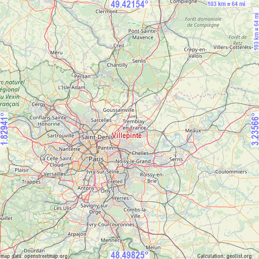
Villepinte GPS coordinates[2]
48° 57' 43.308" North, 2° 31' 57.108" East
| Map corner | latitude | longitude |
|---|---|---|
| Upper-left | 49.42154°, | 1.82941° |
| Center: | 48.96203°, | 2.53253° |
| Lower-right: | 48.49825°, | 3.23566° |
| Map W x H: | 102.7×102.7 km | = 63.8×63.8mi |
| max Lat: | 51.07786° ⇑21.2% North |
| Villepinte: | 48.96203° |
| min Lat: | ⇓78.8% South 41.3874° |
| min Long | Villepinte | max Long |
| -5.08615° | 2.53253° | 9.52242° |
| W 51.1%⇐ | ⇒48.9% E |
Elevation
Elevation of Villepinte is 57 m = 187 ft, and this is 136.7 m = 448 ft below average elevation for this country.
| Max E: |
2333 m = 7654 ft | 79% |
| Avg. | 193.7 m = 635 ft | |
| Villepinte | 57 m = 187 ft | |
Min E: |
-1 m = -3 ft | 21% |
See also: France elevation on elevation.city.
Geographical zone
Villepinte is located in North temperate zone (between Tropic of Cancer and the Arctic Circle). Distance of this North polar circle is 1957.1 km =1216.1 mi to North.| Distance of | km | miles | from Villepinte |
|---|---|---|---|
| North Pole | 4563 | 2835.3 | to North |
| Arctic Circle | 1957.1 | 1216.1 | to North |
| Tropic Cancer | 2838.1 | 1763.5 | to South |
| Equator | 5444.1 | 3382.8 | to South |


Nearby cities:
15 places around Villepinte: (largest is in red/bold)
• Aulnay-sous-Bois
3.9 km =2.4 mi,  226°
226°
• Clichy-sous-Bois
6 km =3.7 mi,  165°
165°
• Coubron
6.3 km =3.9 mi,  143°
143°
• Gonesse
6.7 km =4.2 mi,  294°
294°
• Le Blanc-Mesnil
5.8 km =3.6 mi,  243°
243°
• Le Raincy
7 km =4.3 mi,  185°
185°
• Le Thillay
6.6 km =4.1 mi,  318°
318°
• Les Pavillons-sous-Bois
6.4 km =4 mi,  197°
197°
• Livry-Gargan
4.8 km =3 mi, 170°
• Mitry-Mory
6.6 km =4.1 mi,  68°
68°
• Roissy-en-France
4.8 km =3 mi,  346°
346°
• Sevran
2 km =1.2 mi, 190°
• Tremblay-en-France
3 km =1.9 mi,  117°
117°
• Vaujours
4.5 km =2.8 mi, 141°
• Villeparisis
6.4 km =4 mi,  110°
110°
Sources, notices
• [Note1] Compared only with cities in France existing in our database
• [Src1] Map data: © OpenStreetMap contributors (CC-BY-SA)
• [Src2] Other city data from geonames.org with taken over terms of usage.
• [Src3] Geographical zone / Annual Mean Temperature by Robert A. Rohde @ Wikipedia
