Sevran geodata
Sevran (Île-de-France) is a populated place; located in France in Europe/Paris (GMT+2) time zone. With population of 47,334 people, there are 133 cities with bigger population in this country. Compared to other cities in France, 78.4% of cities are located further ↓South; 51% of cities are located further ←West and 79.8% of cities have higher elevation than Sevran. Note1
Administrative division(s):
- Level 1: Île-de-France
- Level 2: Seine-Saint-Denis
- Level 3: Arrondissement du Raincy
- Level 4: Sevran


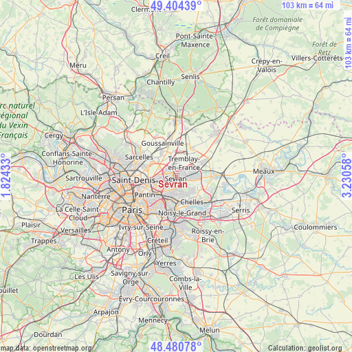
Sevran GPS coordinates[2]
48° 56' 40.992" North, 2° 31' 38.856" East
| Map corner | latitude | longitude |
|---|---|---|
| Upper-left | 49.40439°, | 1.82433° |
| Center: | 48.94472°, | 2.52746° |
| Lower-right: | 48.48078°, | 3.23058° |
| Map W x H: | 102.7×102.7 km | = 63.8×63.8mi |
| max Lat: | 51.07786° ⇑21.6% North |
| Sevran: | 48.94472° |
| min Lat: | ⇓78.4% South 41.3874° |
| min Long | Sevran | max Long |
| -5.08615° | 2.52746° | 9.52242° |
| W 51%⇐ | ⇒49% E |
Elevation
Elevation of Sevran is 55 m = 180 ft, and this is 138.7 m = 455 ft below average elevation for this country.
| Max E: |
2333 m = 7654 ft | 79.8% |
| Avg. | 193.7 m = 635 ft | |
| Sevran | 55 m = 180 ft | |
Min E: |
-1 m = -3 ft | 20.2% |
See also: Sevran elevation on elevation.city.
Geographical zone
Sevran is located in North temperate zone (between Tropic of Cancer and the Arctic Circle). Distance of this North polar circle is 1959 km =1217.3 mi to North.| Distance of | km | miles | from Sevran |
|---|---|---|---|
| North Pole | 4564.9 | 2836.5 | to North |
| Arctic Circle | 1959 | 1217.3 | to North |
| Tropic Cancer | 2836.2 | 1762.3 | to South |
| Equator | 5442.1 | 3381.6 | to South |


Nearby cities:
15 places around Sevran: (largest is in red/bold)
• Aulnay-sous-Bois
2.5 km =1.6 mi,  253°
253°
• Bondy
5.5 km =3.4 mi,  210°
210°
• Clichy-sous-Bois
4.3 km =2.7 mi,  153°
153°
• Coubron
5.1 km =3.2 mi,  127°
127°
• Courtry
6.3 km =3.9 mi,  116°
116°
• Drancy
6.4 km =4 mi, 250°
• Le Blanc-Mesnil
4.9 km =3 mi,  262°
262°
• Le Raincy
5.1 km =3.2 mi,  183°
183°
• Les Pavillons-sous-Bois
4.5 km =2.8 mi,  199°
199°
• Livry-Gargan
3 km =1.9 mi,  158°
158°
• Montfermeil
6.4 km =4 mi,  143°
143°
• Tremblay-en-France
3 km =1.9 mi,  79°
79°
• Vaujours
3.6 km =2.2 mi, 116°
• Villeparisis
6.4 km =4 mi,  92°
92°
• Villepinte
2 km =1.2 mi,  10°
10°
Sources, notices
• [Note1] Compared only with cities in France existing in our database
• [Src1] Map data: © OpenStreetMap contributors (CC-BY-SA)
• [Src2] Other city data from geonames.org with taken over terms of usage.
• [Src3] Geographical zone / Annual Mean Temperature by Robert A. Rohde @ Wikipedia
