Rohan geodata
Rohan (Brittany) is a populated place; located in France in Europe/Paris (GMT+2) time zone. With population of 1,639 people, there are 5698 cities with bigger population in this country. Compared to other cities in France, 60.6% of cities are located further ↓South; 96.7% of cities are located further →East and 75% of cities have higher elevation than Rohan. Note1
Administrative division(s):
- Level 1: Brittany
- Level 2: Morbihan
- Level 3: Arrondissement de Pontivy
- Level 4: Rohan


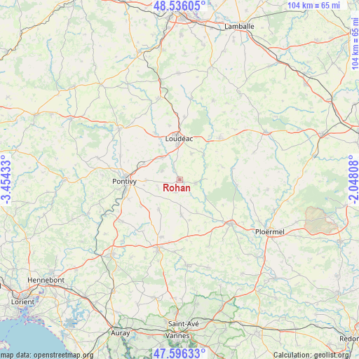
Rohan GPS coordinates[2]
48° 4' 5.988" North, 2° 45' 4.32" West
| Map corner | latitude | longitude |
|---|---|---|
| Upper-left | 48.53605°, | -3.45433° |
| Center: | 48.06833°, | -2.7512° |
| Lower-right: | 47.59633°, | -2.04808° |
| Map W x H: | 104.5×104.5 km | = 64.9×64.9mi |
| max Lat: | 51.07786° ⇑39.4% North |
| Rohan: | 48.06833° |
| min Lat: | ⇓60.6% South 41.3874° |
| min Long | Rohan | max Long |
| -5.08615° | -2.7512° | 9.52242° |
| W 3.3%⇐ | ⇒96.7% E |
Elevation
Elevation of Rohan is 67 m = 220 ft, and this is 126.7 m = 416 ft below average elevation for this country.
| Max E: |
2333 m = 7654 ft | 75% |
| Avg. | 193.7 m = 635 ft | |
| Rohan | 67 m = 220 ft | |
Min E: |
-1 m = -3 ft | 25% |
See also: France elevation on elevation.city.
Geographical zone
Rohan is located in North temperate zone (between Tropic of Cancer and the Arctic Circle). Distance of this North polar circle is 2056.5 km =1277.8 mi to North.| Distance of | km | miles | from Rohan |
|---|---|---|---|
| North Pole | 4662.4 | 2897.1 | to North |
| Arctic Circle | 2056.5 | 1277.8 | to North |
| Tropic Cancer | 2738.8 | 1701.8 | to South |
| Equator | 5344.7 | 3321 | to South |


Nearby cities:
15 places around Rohan: (largest is in red/bold)
• Crédin
3.9 km =2.4 mi,  196°
196°
• Gueltas
4.5 km =2.8 mi,  311°
311°
• Hémonstoir
11.6 km =7.2 mi,  329°
329°
• Kerfourn
6.7 km =4.2 mi,  245°
245°
• La Chèze
9.9 km =6.2 mi,  45°
45°
• Le Cambout
10.5 km =6.5 mi,  95°
95°
• Loudéac
12.2 km =7.6 mi,  358°
358°
• Naizin
10.6 km =6.6 mi,  214°
214°
• Noyal-Pontivy
9.8 km =6.1 mi,  268°
268°
• Pleugriffet
10.4 km =6.5 mi,  151°
151°
• Radenac
12 km =7.5 mi,  166°
166°
• Réguiny
10.2 km =6.3 mi,  177°
177°
• Saint-Barnabé
8.4 km =5.2 mi,  24°
24°
• Saint-Gonnery
8 km =5 mi,  321°
321°
• Saint-Gérand
11.3 km =7 mi,  293°
293°
Sources, notices
• [Note1] Compared only with cities in France existing in our database
• [Src1] Map data: © OpenStreetMap contributors (CC-BY-SA)
• [Src2] Other city data from geonames.org with taken over terms of usage.
• [Src3] Geographical zone / Annual Mean Temperature by Robert A. Rohde @ Wikipedia
