Roffiac geodata
Roffiac (Auvergne-Rhône-Alpes) is a populated place; located in France in Europe/Paris (GMT+2) time zone. With population of 574 people, there are 13763 cities with bigger population in this country. Compared to other cities in France, 79.1% of cities are located further ↑North; 58.3% of cities are located further ←West and 98% of cities have lower elevation than Roffiac. Note1
Administrative division(s):
- Level 1: Auvergne-Rhône-Alpes
- Level 2: Cantal
- Level 3: Arrondissement de Saint-Flour
- Level 4: Roffiac


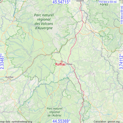
Roffiac GPS coordinates[2]
45° 3' 9.288" North, 3° 2' 16.764" East
| Map corner | latitude | longitude |
|---|---|---|
| Upper-left | 45.54715°, | 2.33487° |
| Center: | 45.05258°, | 3.03799° |
| Lower-right: | 44.55369°, | 3.74112° |
| Map W x H: | 110.5×110.5 km | = 68.7×68.7mi |
| max Lat: | 51.07786° ⇑79.1% North |
| Roffiac: | 45.05258° |
| min Lat: | ⇓20.9% South 41.3874° |
| min Long | Roffiac | max Long |
| -5.08615° | 3.03799° | 9.52242° |
| W 58.3%⇐ | ⇒41.7% E |
Elevation
Elevation of Roffiac is 826 m = 2710 ft, and this is 632.3 m = 2074 ft above average elevation for this country.
| Max E: |
2333 m = 7654 ft | 2% |
| Roffiac | 826 m 2710 ft | |
| Avg. | 193.7 m = 635 ft | |
Min E: |
-1 m = -3 ft | 98% |
See also: France elevation on elevation.city.
Geographical zone
Roffiac is located in North temperate zone (between Tropic of Cancer and the Arctic Circle). Distance of this North polar circle is 2391.8 km =1486.2 mi to North.| Distance of | km | miles | from Roffiac |
|---|---|---|---|
| North Pole | 4997.7 | 3105.4 | to North |
| Arctic Circle | 2391.8 | 1486.2 | to North |
| Tropic Cancer | 2403.5 | 1493.5 | to South |
| Equator | 5009.4 | 3112.7 | to South |


Nearby cities:
15 places around Roffiac: (largest is in red/bold)
• Allanche
21.2 km =13.2 mi,  337°
337°
• Blesle
31.4 km =19.5 mi,  19°
19°
• Chaudes-Aigues
22.2 km =13.8 mi,  186°
186°
• Laveissière
19.4 km =12.1 mi,  291°
291°
• Le Malzieu-Ville
31.8 km =19.8 mi,  133°
133°
• Massiac
25.4 km =15.8 mi,  29°
29°
• Murat
14.8 km =9.2 mi,  295°
295°
• Neussargues
9.7 km =6 mi,  330°
330°
• Neuvéglise
14.5 km =9 mi,  197°
197°
• Pierrefort
21.4 km =13.3 mi,  227°
227°
• Saint-Flour
4.8 km =3 mi,  115°
115°
• Talizat
6.9 km =4.3 mi,  5°
5°
• Thiézac
29.6 km =18.4 mi,  261°
261°
• Valuéjols
8.2 km =5.1 mi,  270°
270°
• Villedieu
6.3 km =3.9 mi,  160°
160°
Sources, notices
• [Note1] Compared only with cities in France existing in our database
• [Src1] Map data: © OpenStreetMap contributors (CC-BY-SA)
• [Src2] Other city data from geonames.org with taken over terms of usage.
• [Src3] Geographical zone / Annual Mean Temperature by Robert A. Rohde @ Wikipedia
