Saint-Flour geodata
Saint-Flour (Auvergne-Rhône-Alpes) is a seat of a third-order administrative division; located in France in Europe/Paris (GMT+2) time zone. With population of 7,499 people, there are 1299 cities with bigger population in this country. Compared to other cities in France, 79.3% of cities are located further ↑North; 59.2% of cities are located further ←West and 97.8% of cities have lower elevation than Saint-Flour. Note1
Administrative division(s):
- Level 1: Auvergne-Rhône-Alpes
- Level 2: Cantal
- Level 3: Arrondissement de Saint-Flour
- Level 4: Saint-Flour


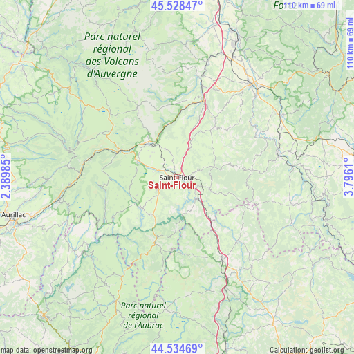
Saint-Flour GPS coordinates[2]
45° 2' 1.464" North, 3° 5' 34.692" East
| Map corner | latitude | longitude |
|---|---|---|
| Upper-left | 45.52847°, | 2.38985° |
| Center: | 45.03374°, | 3.09297° |
| Lower-right: | 44.53469°, | 3.7961° |
| Map W x H: | 110.5×110.5 km | = 68.7×68.7mi |
| max Lat: | 51.07786° ⇑79.3% North |
| Saint-Flour: | 45.03374° |
| min Lat: | ⇓20.7% South 41.3874° |
| min Long | Saint-Flour | max Long |
| -5.08615° | 3.09297° | 9.52242° |
| W 59.2%⇐ | ⇒40.8% E |
Elevation
Elevation of Saint-Flour is 799 m = 2621 ft, and this is 605.3 m = 1986 ft above average elevation for this country.
| Max E: |
2333 m = 7654 ft | 2.2% |
| Saint-Flour | 799 m 2621 ft | |
| Avg. | 193.7 m = 635 ft | |
Min E: |
-1 m = -3 ft | 97.8% |
See also: France elevation on elevation.city.
Geographical zone
Saint-Flour is located in North temperate zone (between Tropic of Cancer and the Arctic Circle). Distance of this North polar circle is 2393.9 km =1487.5 mi to North.| Distance of | km | miles | from Saint-Flour |
|---|---|---|---|
| North Pole | 4999.8 | 3106.7 | to North |
| Arctic Circle | 2393.9 | 1487.5 | to North |
| Tropic Cancer | 2401.4 | 1492.2 | to South |
| Equator | 5007.3 | 3111.4 | to South |


Nearby cities:
15 places around Saint-Flour: (largest is in red/bold)
• Allanche
25 km =15.5 mi,  330°
330°
• Blesle
32.3 km =20.1 mi,  10°
10°
• Chaudes-Aigues
21.1 km =13.1 mi,  199°
199°
• Laveissière
24.2 km =15 mi,  292°
292°
• Le Malzieu-Ville
27.3 km =17 mi,  136°
136°
• Massiac
25.6 km =15.9 mi,  18°
18°
• Murat
19.6 km =12.2 mi,  295°
295°
• Neussargues
13.9 km =8.6 mi,  318°
318°
• Neuvéglise
14.6 km =9.1 mi,  216°
216°
• Pierrefort
23.6 km =14.7 mi,  238°
238°
• Roffiac
4.8 km =3 mi, 295°
• Saint-Chély-d’Apcher
29.1 km =18.1 mi,  150°
150°
• Talizat
9.6 km =6 mi,  338°
338°
• Valuéjols
12.7 km =7.9 mi,  279°
279°
• Villedieu
4.5 km =2.8 mi,  210°
210°
Sources, notices
• [Note1] Compared only with cities in France existing in our database
• [Src1] Map data: © OpenStreetMap contributors (CC-BY-SA)
• [Src2] Other city data from geonames.org with taken over terms of usage.
• [Src3] Geographical zone / Annual Mean Temperature by Robert A. Rohde @ Wikipedia
