Chaudes-Aigues geodata
Chaudes-Aigues (Auvergne-Rhône-Alpes) is a populated place; located in France in Europe/Paris (GMT+2) time zone. With population of 1,012 people, there are 8758 cities with bigger population in this country. Compared to other cities in France, 80.9% of cities are located further ↑North; 57.9% of cities are located further ←West and 98.1% of cities have lower elevation than Chaudes-Aigues. Note1
Administrative division(s):
- Level 1: Auvergne-Rhône-Alpes
- Level 2: Cantal
- Level 3: Arrondissement de Saint-Flour
- Level 4: Chaudes-Aigues


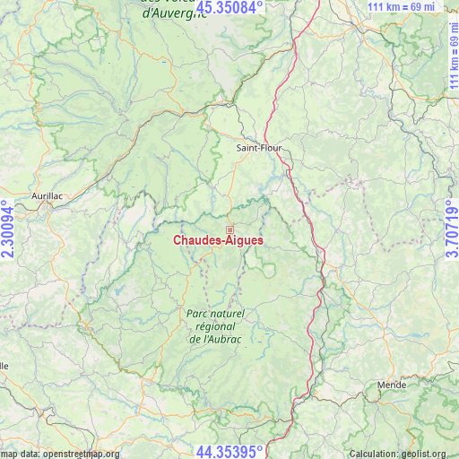
Chaudes-Aigues GPS coordinates[2]
44° 51' 16.38" North, 3° 0' 14.616" East
| Map corner | latitude | longitude |
|---|---|---|
| Upper-left | 45.35084°, | 2.30094° |
| Center: | 44.85455°, | 3.00406° |
| Lower-right: | 44.35395°, | 3.70719° |
| Map W x H: | 110.8×110.8 km | = 68.8×68.8mi |
| max Lat: | 51.07786° ⇑80.9% North |
| Chaudes-Aigues: | 44.85455° |
| min Lat: | ⇓19.1% South 41.3874° |
| min Long | Chaudes-Aigues | max Long |
| -5.08615° | 3.00406° | 9.52242° |
| W 57.9%⇐ | ⇒42.1% E |
Elevation
Elevation of Chaudes-Aigues is 837 m = 2746 ft, and this is 643.3 m = 2111 ft above average elevation for this country.
| Max E: |
2333 m = 7654 ft | 1.9% |
| Chaudes-Aigues | 837 m 2746 ft | |
| Avg. | 193.7 m = 635 ft | |
Min E: |
-1 m = -3 ft | 98.1% |
See also: France elevation on elevation.city.
Geographical zone
Chaudes-Aigues is located in North temperate zone (between Tropic of Cancer and the Arctic Circle). Distance of this Northern Tropic circle is 2381.4 km =1479.7 mi to South.| Distance of | km | miles | from Chaudes-Aigues |
|---|---|---|---|
| North Pole | 5019.7 | 3119.1 | to North |
| Arctic Circle | 2413.8 | 1499.9 | to North |
| Tropic Cancer | 2381.4 | 1479.7 | to South |
| Equator | 4987.4 | 3099 | to South |


Nearby cities:
15 places around Chaudes-Aigues: (largest is in red/bold)
• Aumont-Aubrac
26.6 km =16.5 mi,  123°
123°
• Brommat
25.4 km =15.8 mi,  263°
263°
• Laguiole
22.6 km =14 mi,  213°
213°
• Le Malzieu-Ville
25.9 km =16.1 mi,  89°
89°
• Mur-de-Barrez
27.1 km =16.8 mi,  267°
267°
• Nasbinals
21.6 km =13.4 mi,  170°
170°
• Neuvéglise
8.3 km =5.2 mi,  348°
348°
• Pierrefort
15.1 km =9.4 mi,  299°
299°
• Roffiac
22.2 km =13.8 mi,  6°
6°
• Saint-Chély-d’Apcher
22 km =13.7 mi,  104°
104°
• Saint-Flour
21.1 km =13.1 mi,  19°
19°
• Saint-Urcize
17.6 km =10.9 mi,  180°
180°
• Sainte-Geneviève-sur-Argence
20.1 km =12.5 mi,  253°
253°
• Valuéjols
22.7 km =14.1 mi, 345°
• Villedieu
16.7 km =10.4 mi, 16°
Sources, notices
• [Note1] Compared only with cities in France existing in our database
• [Src1] Map data: © OpenStreetMap contributors (CC-BY-SA)
• [Src2] Other city data from geonames.org with taken over terms of usage.
• [Src3] Geographical zone / Annual Mean Temperature by Robert A. Rohde @ Wikipedia
