Boust geodata
Boust (Grand Est) is a populated place; located in France in Europe/Paris (GMT+2) time zone. With population of 746 people, there are 11210 cities with bigger population in this country. Compared to other cities in France, 88.4% of cities are located further ↓South; 89.2% of cities are located further ←West and 63.1% of cities have lower elevation than Boust. Note1
Administrative division(s):
- Level 1: Grand Est
- Level 2: Moselle
- Level 3: Arrondissement de Thionville
- Level 4: Boust


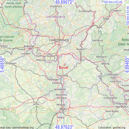
Boust GPS coordinates[2]
49° 26' 8.196" North, 6° 11' 30.12" East
| Map corner | latitude | longitude |
|---|---|---|
| Upper-left | 49.89072°, | 5.48858° |
| Center: | 49.43561°, | 6.1917° |
| Lower-right: | 48.97623°, | 6.89483° |
| Map W x H: | 101.7×101.7 km | = 63.2×63.2mi |
| max Lat: | 51.07786° ⇑11.6% North |
| Boust: | 49.43561° |
| min Lat: | ⇓88.4% South 41.3874° |
| min Long | Boust | max Long |
| -5.08615° | 6.1917° | 9.52242° |
| W 89.2%⇐ | ⇒10.8% E |
Elevation
Elevation of Boust is 185 m = 607 ft, and this is 8.7 m = 29 ft below average elevation for this country.
| Max E: |
2333 m = 7654 ft | 36.9% |
| Avg. | 193.7 m = 635 ft | |
| Boust | 185 m = 607 ft | |
Min E: |
-1 m = -3 ft | 63.1% |
See also: France elevation on elevation.city.
Geographical zone
Boust is located in North temperate zone (between Tropic of Cancer and the Arctic Circle). Distance of this North polar circle is 1904.4 km =1183.3 mi to North.| Distance of | km | miles | from Boust |
|---|---|---|---|
| North Pole | 4510.3 | 2802.6 | to North |
| Arctic Circle | 1904.4 | 1183.3 | to North |
| Tropic Cancer | 2890.8 | 1796.3 | to South |
| Equator | 5496.7 | 3415.5 | to South |


Nearby cities:
15 places around Boust: (largest is in red/bold)
• Basse-Ham
6.6 km =4.1 mi,  146°
146°
• Cattenom
4.9 km =3 mi,  131°
131°
• Entrange
6.8 km =4.2 mi,  248°
248°
• Gavisse
6.9 km =4.3 mi,  92°
92°
• Hettange-Grande
4.3 km =2.7 mi,  221°
221°
• Kanfen
6 km =3.7 mi,  273°
273°
• Kœnigsmacker
7.7 km =4.8 mi,  120°
120°
• Malling
7.7 km =4.8 mi,  100°
100°
• Manom
7.2 km =4.5 mi,  184°
184°
• Puttelange-lès-Thionville
7.6 km =4.7 mi,  43°
43°
• Rodemack
5 km =3.1 mi, 39°
• Roussy-le-Village
2.7 km =1.7 mi,  332°
332°
• Thionville
8.7 km =5.4 mi,  195°
195°
• Volmerange-les-Mines
8.1 km =5 mi,  276°
276°
• Zoufftgen
5.1 km =3.2 mi,  304°
304°
Sources, notices
• [Note1] Compared only with cities in France existing in our database
• [Src1] Map data: © OpenStreetMap contributors (CC-BY-SA)
• [Src2] Other city data from geonames.org with taken over terms of usage.
• [Src3] Geographical zone / Annual Mean Temperature by Robert A. Rohde @ Wikipedia
