Arengosse geodata
Arengosse (Nouvelle-Aquitaine) is a populated place; located in France in Europe/Paris (GMT+2) time zone. With population of 736 people, there are 11334 cities with bigger population in this country. Compared to other cities in France, 87% of cities are located further ↑North; 86.3% of cities are located further →East and 69.7% of cities have higher elevation than Arengosse. Note1
Administrative division(s):
- Level 1: Nouvelle-Aquitaine
- Level 2: Landes
- Level 3: Arrondissement de Mont-de-Marsan
- Level 4: Arengosse


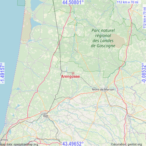
Arengosse GPS coordinates[2]
44° 0' 15.912" North, 0° 47' 18.384" West
| Map corner | latitude | longitude |
|---|---|---|
| Upper-left | 44.50801°, | -1.49157° |
| Center: | 44.00442°, | -0.78844° |
| Lower-right: | 43.49652°, | -0.08532° |
| Map W x H: | 112.5×112.5 km | = 69.9×69.9mi |
| max Lat: | 51.07786° ⇑87% North |
| Arengosse: | 44.00442° |
| min Lat: | ⇓13% South 41.3874° |
| min Long | Arengosse | max Long |
| -5.08615° | -0.78844° | 9.52242° |
| W 13.7%⇐ | ⇒86.3% E |
Elevation
Elevation of Arengosse is 79 m = 259 ft, and this is 114.7 m = 376 ft below average elevation for this country.
| Max E: |
2333 m = 7654 ft | 69.7% |
| Avg. | 193.7 m = 635 ft | |
| Arengosse | 79 m = 259 ft | |
Min E: |
-1 m = -3 ft | 30.3% |
See also: France elevation on elevation.city.
Geographical zone
Arengosse is located in North temperate zone (between Tropic of Cancer and the Arctic Circle). Distance of this Northern Tropic circle is 2286.9 km =1421 mi to South.| Distance of | km | miles | from Arengosse |
|---|---|---|---|
| North Pole | 5114.2 | 3177.8 | to North |
| Arctic Circle | 2508.3 | 1558.6 | to North |
| Tropic Cancer | 2286.9 | 1421 | to South |
| Equator | 4892.8 | 3040.2 | to South |


Nearby cities:
15 places around Arengosse: (largest is in red/bold)
• Brocas
21 km =13 mi,  77°
77°
• Bégaar
20.7 km =12.9 mi,  193°
193°
• Campagne
19.6 km =12.2 mi,  142°
142°
• Carcen-Ponson
13.7 km =8.5 mi, 186°
• Geloux
12.2 km =7.6 mi,  102°
102°
• Labrit
22.4 km =13.9 mi,  60°
60°
• Meilhan
16.9 km =10.5 mi,  156°
156°
• Morcenx
10.6 km =6.6 mi,  288°
288°
• Onesse-Laharie
23.4 km =14.5 mi, 285°
• Rion-des-Landes
13.3 km =8.3 mi,  234°
234°
• Sabres
16.5 km =10.3 mi,  13°
13°
• Saint-Perdon
22.1 km =13.7 mi,  134°
134°
• Tartas
19.2 km =11.9 mi,  184°
184°
• Uchacq-et-Parentis
20.2 km =12.6 mi,  115°
115°
• Ygos-Saint-Saturnin
5.1 km =3.2 mi, 127°
Sources, notices
• [Note1] Compared only with cities in France existing in our database
• [Src1] Map data: © OpenStreetMap contributors (CC-BY-SA)
• [Src2] Other city data from geonames.org with taken over terms of usage.
• [Src3] Geographical zone / Annual Mean Temperature by Robert A. Rohde @ Wikipedia
