Rânes geodata
Rânes (Normandy) is a populated place; located in France in Europe/Paris (GMT+2) time zone. With population of 982 people, there are 8971 cities with bigger population in this country. Compared to other cities in France, 71.8% of cities are located further ↓South; 79.7% of cities are located further →East and 74.9% of cities have lower elevation than Rânes. Note1
Administrative division(s):
- Level 1: Normandy
- Level 2: Département de l'Orne
- Level 3: Argentan
- Level 4: Rânes


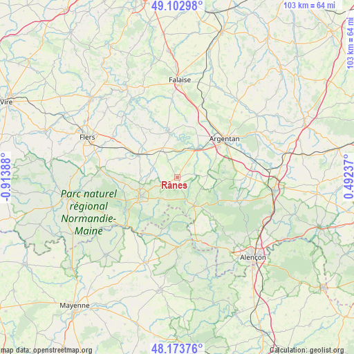
Rânes GPS coordinates[2]
48° 38' 25.836" North, 0° 12' 38.736" West
| Map corner | latitude | longitude |
|---|---|---|
| Upper-left | 49.10298°, | -0.91388° |
| Center: | 48.64051°, | -0.21076° |
| Lower-right: | 48.17376°, | 0.49237° |
| Map W x H: | 103.3×103.3 km | = 64.2×64.2mi |
| max Lat: | 51.07786° ⇑28.2% North |
| Rânes: | 48.64051° |
| min Lat: | ⇓71.8% South 41.3874° |
| min Long | Rânes | max Long |
| -5.08615° | -0.21076° | 9.52242° |
| W 20.3%⇐ | ⇒79.7% E |
Elevation
Elevation of Rânes is 248 m = 814 ft, and this is 54.3 m = 178 ft above average elevation for this country.
| Max E: |
2333 m = 7654 ft | 25.1% |
| Rânes | 248 m 814 ft | |
| Avg. | 193.7 m = 635 ft | |
Min E: |
-1 m = -3 ft | 74.9% |
See also: France elevation on elevation.city.
Geographical zone
Rânes is located in North temperate zone (between Tropic of Cancer and the Arctic Circle). Distance of this North polar circle is 1992.9 km =1238.3 mi to North.| Distance of | km | miles | from Rânes |
|---|---|---|---|
| North Pole | 4598.7 | 2857.5 | to North |
| Arctic Circle | 1992.9 | 1238.3 | to North |
| Tropic Cancer | 2802.4 | 1741.3 | to South |
| Equator | 5408.3 | 3360.6 | to South |


Nearby cities:
15 places around Rânes: (largest is in red/bold)
• Bagnoles-de-l'Orne
17.6 km =10.9 mi,  238°
238°
• Bellou-en-Houlme
17.9 km =11.1 mi,  288°
288°
• Boucé
8.9 km =5.5 mi,  85°
85°
• Briouze
13.2 km =8.2 mi,  299°
299°
• Carrouges
9.4 km =5.8 mi,  149°
149°
• Courteilles
15 km =9.3 mi,  3°
3°
• La Ferté-Macé
12.2 km =7.6 mi, 242°
• La Sauvagère
15.2 km =9.4 mi,  262°
262°
• Lignières-Orgères
10.9 km =6.8 mi,  178°
178°
• Magny-le-Désert
11.6 km =7.2 mi,  227°
227°
• Pont-Écrepin
14 km =8.7 mi,  349°
349°
• Putanges-Pont-Écrepin
14.3 km =8.9 mi, 348°
• Saint-Maurice-du-Désert
13.5 km =8.4 mi, 255°
• Sarceaux
15.2 km =9.4 mi,  55°
55°
• Écouché
10.7 km =6.6 mi,  36°
36°
Sources, notices
• [Note1] Compared only with cities in France existing in our database
• [Src1] Map data: © OpenStreetMap contributors (CC-BY-SA)
• [Src2] Other city data from geonames.org with taken over terms of usage.
• [Src3] Geographical zone / Annual Mean Temperature by Robert A. Rohde @ Wikipedia
