Lignières-Orgères geodata
Lignières-Orgères (Pays de la Loire) is a populated place; located in France in Europe/Paris (GMT+2) time zone. With population of 769 people, there are 10958 cities with bigger population in this country. Compared to other cities in France, 69.3% of cities are located further ↓South; 79.7% of cities are located further →East and 79.4% of cities have lower elevation than Lignières-Orgères. Note1
Administrative division(s):
- Level 1: Pays de la Loire
- Level 2: Mayenne
- Level 3: Arrondissement de Mayenne
- Level 4: Lignières-Orgères


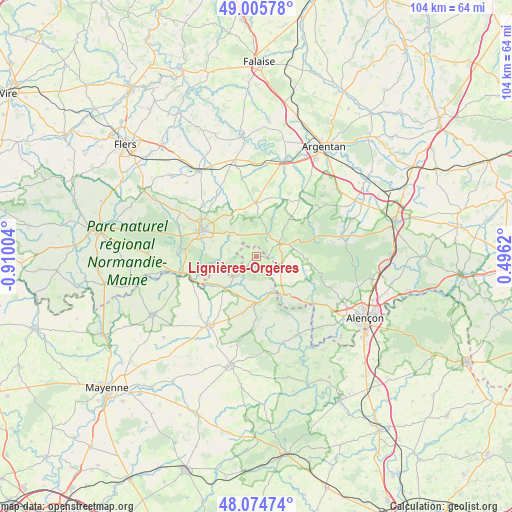
Lignières-Orgères GPS coordinates[2]
48° 32' 32.64" North, 0° 12' 24.912" West
| Map corner | latitude | longitude |
|---|---|---|
| Upper-left | 49.00578°, | -0.91004° |
| Center: | 48.5424°, | -0.20692° |
| Lower-right: | 48.07474°, | 0.4962° |
| Map W x H: | 103.5×103.5 km | = 64.3×64.3mi |
| max Lat: | 51.07786° ⇑30.7% North |
| Lignières-Orgères: | 48.5424° |
| min Lat: | ⇓69.3% South 41.3874° |
| min Long | Lignières-Org� | max Long |
| -5.08615° | -0.20692° | 9.52242° |
| W 20.3%⇐ | ⇒79.7% E |
Elevation
Elevation of Lignières-Orgères is 284 m = 932 ft, and this is 90.3 m = 296 ft above average elevation for this country.
| Max E: |
2333 m = 7654 ft | 20.6% |
| Lignières-Orgères | 284 m 932 ft | |
| Avg. | 193.7 m = 635 ft | |
Min E: |
-1 m = -3 ft | 79.4% |
See also: France elevation on elevation.city.
Geographical zone
Lignières-Orgères is located in North temperate zone (between Tropic of Cancer and the Arctic Circle). Distance of this North polar circle is 2003.8 km =1245.1 mi to North.| Distance of | km | miles | from Lignières-Orgères |
|---|---|---|---|
| North Pole | 4609.7 | 2864.3 | to North |
| Arctic Circle | 2003.8 | 1245.1 | to North |
| Tropic Cancer | 2791.5 | 1734.6 | to South |
| Equator | 5397.4 | 3353.8 | to South |


Nearby cities:
15 places around Lignières-Orgères: (largest is in red/bold)
• Bagnoles-de-l'Orne
15.3 km =9.5 mi,  276°
276°
• Boucé
14.4 km =8.9 mi,  36°
36°
• Carrouges
5.3 km =3.3 mi,  58°
58°
• Couterne
15.7 km =9.8 mi,  258°
258°
• Javron-les-Chapelles
16.9 km =10.5 mi,  214°
214°
• La Ferrière-Bochard
19.2 km =11.9 mi,  138°
138°
• La Ferté-Macé
12.3 km =7.6 mi,  295°
295°
• La Sauvagère
17.8 km =11.1 mi, 300°
• Magny-le-Désert
9.4 km =5.8 mi,  289°
289°
• Pré-en-Pail
9.2 km =5.7 mi,  175°
175°
• Rânes
10.9 km =6.8 mi,  358°
358°
• Saint-Denis-sur-Sarthon
15.4 km =9.6 mi,  130°
130°
• Saint-Maurice-du-Désert
15.4 km =9.6 mi, 299°
• Saint-Pierre-des-Nids
17.9 km =11.1 mi,  153°
153°
• Tessé-la-Madeleine
16.1 km =10 mi,  272°
272°
Sources, notices
• [Note1] Compared only with cities in France existing in our database
• [Src1] Map data: © OpenStreetMap contributors (CC-BY-SA)
• [Src2] Other city data from geonames.org with taken over terms of usage.
• [Src3] Geographical zone / Annual Mean Temperature by Robert A. Rohde @ Wikipedia
