Bagnoles-de-l'Orne geodata
Bagnoles-de-l'Orne (Normandy) is a populated place; located in France in Europe/Paris (GMT+2) time zone. With population of 2,454 people, there are 3952 cities with bigger population in this country. Compared to other cities in France, 69.7% of cities are located further ↓South; 82.3% of cities are located further →East and 64.4% of cities have lower elevation than Bagnoles-de-l'Orne. Note1
Administrative division(s):
- Level 1: Normandy
- Level 2: Département de l'Orne
- Level 3: Arrondissement d’Alençon
- Level 4: Bagnoles de l'Orne Normandie


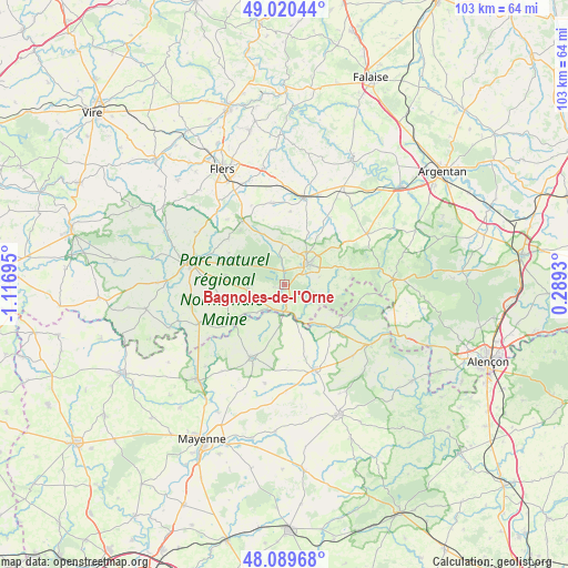
Bagnoles-de-l'Orne GPS coordinates[2]
48° 33' 25.92" North, 0° 24' 49.788" West
| Map corner | latitude | longitude |
|---|---|---|
| Upper-left | 49.02044°, | -1.11695° |
| Center: | 48.5572°, | -0.41383° |
| Lower-right: | 48.08968°, | 0.2893° |
| Map W x H: | 103.5×103.5 km | = 64.3×64.3mi |
| max Lat: | 51.07786° ⇑30.3% North |
| Bagnoles-de-l'Orne: | 48.5572° |
| min Lat: | ⇓69.7% South 41.3874° |
| min Long | Bagnoles-de-l'O | max Long |
| -5.08615° | -0.41383° | 9.52242° |
| W 17.7%⇐ | ⇒82.3% E |
Elevation
Elevation of Bagnoles-de-l'Orne is 191 m = 627 ft, and this is 2.7 m = 9 ft below average elevation for this country.
| Max E: |
2333 m = 7654 ft | 35.6% |
| Avg. | 193.7 m = 635 ft | |
| Bagnoles-de-l'Orne | 191 m = 627 ft | |
Min E: |
-1 m = -3 ft | 64.4% |
See also: France elevation on elevation.city.
Geographical zone
Bagnoles-de-l'Orne is located in North temperate zone (between Tropic of Cancer and the Arctic Circle). Distance of this North polar circle is 2002.1 km =1244 mi to North.| Distance of | km | miles | from Bagnoles-de-l'Orne |
|---|---|---|---|
| North Pole | 4608 | 2863.3 | to North |
| Arctic Circle | 2002.1 | 1244 | to North |
| Tropic Cancer | 2793.1 | 1735.6 | to South |
| Equator | 5399.1 | 3354.8 | to South |


Nearby cities:
15 places around Bagnoles-de-l'Orne: (largest is in red/bold)
• Bellou-en-Houlme
14.9 km =9.3 mi,  352°
352°
• Briouze
16.1 km =10 mi,  12°
12°
• Champsecret
11.6 km =7.2 mi,  299°
299°
• Couterne
4.9 km =3 mi,  181°
181°
• Javron-les-Chapelles
16.5 km =10.3 mi,  160°
160°
• Juvigny-sous-Andaine
7 km =4.3 mi,  265°
265°
• La Coulonche
10.5 km =6.5 mi,  342°
342°
• La Ferrière-aux-Étangs
14 km =8.7 mi,  326°
326°
• La Ferté-Macé
5.5 km =3.4 mi,  48°
48°
• La Sauvagère
7.4 km =4.6 mi,  358°
358°
• Lassay-les-Châteaux
14.6 km =9.1 mi,  205°
205°
• Lignières-Orgères
15.3 km =9.5 mi,  96°
96°
• Magny-le-Désert
6.5 km =4 mi,  77°
77°
• Saint-Maurice-du-Désert
6.2 km =3.9 mi,  17°
17°
• Tessé-la-Madeleine
1.2 km =0.7 mi,  224°
224°
Sources, notices
• [Note1] Compared only with cities in France existing in our database
• [Src1] Map data: © OpenStreetMap contributors (CC-BY-SA)
• [Src2] Other city data from geonames.org with taken over terms of usage.
• [Src3] Geographical zone / Annual Mean Temperature by Robert A. Rohde @ Wikipedia
