Putanges-Pont-Écrepin geodata
Putanges-Pont-Écrepin (Normandy) is a populated place; located in France in Europe/Paris (GMT+2) time zone. With population of 1,029 people, there are 8622 cities with bigger population in this country. Compared to other cities in France, 74.8% of cities are located further ↓South; 80.3% of cities are located further →East and 51.9% of cities have lower elevation than Putanges-Pont-Écrepin. Note1
Administrative division(s):
- Level 1: Normandy
- Level 2: Département de l'Orne
- Level 3: Argentan
- Level 4: Putanges-le-Lac
Current local time in Putanges-Pont-Écrepin:
07:12 PM, SaturdayDifference from your time zone: hours


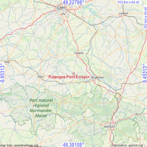
Putanges-Pont-Écrepin GPS coordinates[2]
48° 46' 0.012" North, 0° 15' 0" West
| Map corner | latitude | longitude |
|---|---|---|
| Upper-left | 49.22798°, | -0.95313° |
| Center: | 48.76667°, | -0.25° |
| Lower-right: | 48.30108°, | 0.45313° |
| Map W x H: | 103.1×103.1 km | = 64.1×64.1mi |
| max Lat: | 51.07786° ⇑25.2% North |
| Putanges-Pont-Écrepin: | 48.76667° |
| min Lat: | ⇓74.8% South 41.3874° |
| min Long | Putanges-Pont-� | max Long |
| -5.08615° | -0.25° | 9.52242° |
| W 19.7%⇐ | ⇒80.3% E |
Elevation
Elevation of Putanges-Pont-Écrepin is 139 m = 456 ft, and this is 54.7 m = 179 ft below average elevation for this country.
| Max E: |
2333 m = 7654 ft | 48.1% |
| Avg. | 193.7 m = 635 ft | |
| Putanges-Pont-Écrepin | 139 m = 456 ft | |
Min E: |
-1 m = -3 ft | 51.9% |
See also: France elevation on elevation.city.
Geographical zone
Putanges-Pont-Écrepin is located in North temperate zone (between Tropic of Cancer and the Arctic Circle). Distance of this North polar circle is 1978.8 km =1229.6 mi to North.| Distance of | km | miles | from Putanges-Pont-Écrepin |
|---|---|---|---|
| North Pole | 4584.7 | 2848.8 | to North |
| Arctic Circle | 1978.8 | 1229.6 | to North |
| Tropic Cancer | 2816.4 | 1750 | to South |
| Equator | 5422.3 | 3369.3 | to South |


Nearby cities:
15 places around Putanges-Pont-Écrepin: (largest is in red/bold)
• Argentan
17 km =10.6 mi,  98°
98°
• Bailleul
18.5 km =11.5 mi,  78°
78°
• Bellou-en-Houlme
16.4 km =10.2 mi,  238°
238°
• Boucé
17.8 km =11.1 mi,  138°
138°
• Briouze
11.5 km =7.1 mi,  228°
228°
• Courteilles
3.8 km =2.4 mi, 76°
• Falaise
14.5 km =9 mi,  16°
16°
• La Hoguette
13.8 km =8.6 mi,  27°
27°
• Occagnes
13.1 km =8.1 mi, 83°
• Pont-d'Ouilly
16.5 km =10.3 mi,  317°
317°
• Pont-Écrepin
0.5 km =0.3 mi,  123°
123°
• Rânes
14.3 km =8.9 mi,  168°
168°
• Sainte-Honorine-la-Chardonne
18.4 km =11.4 mi,  290°
290°
• Sarceaux
16.2 km =10.1 mi,  109°
109°
• Écouché
10.7 km =6.6 mi, 120°
Sources, notices
• [Note1] Compared only with cities in France existing in our database
• [Src1] Map data: © OpenStreetMap contributors (CC-BY-SA)
• [Src2] Other city data from geonames.org with taken over terms of usage.
• [Src3] Geographical zone / Annual Mean Temperature by Robert A. Rohde @ Wikipedia
