La Sauvagère geodata
La Sauvagère (Normandy) is a populated place; located in France in Europe/Paris (GMT+2) time zone. With population of 928 people, there are 9405 cities with bigger population in this country. Compared to other cities in France, 71.4% of cities are located further ↓South; 82.3% of cities are located further →East and 76.7% of cities have lower elevation than La Sauvagère. Note1
Administrative division(s):
- Level 1: Normandy
- Level 2: Département de l'Orne
- Level 3: Argentan
- Level 4: Les Monts d'Andaine


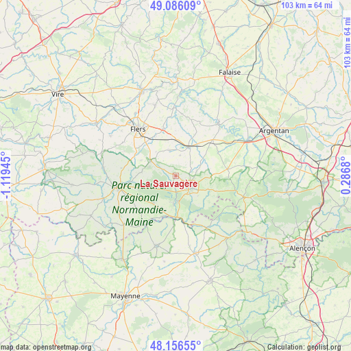
La Sauvagère GPS coordinates[2]
48° 37' 24.456" North, 0° 24' 58.752" West
| Map corner | latitude | longitude |
|---|---|---|
| Upper-left | 49.08609°, | -1.11945° |
| Center: | 48.62346°, | -0.41632° |
| Lower-right: | 48.15655°, | 0.2868° |
| Map W x H: | 103.4×103.4 km | = 64.2×64.2mi |
| max Lat: | 51.07786° ⇑28.6% North |
| La Sauvagère: | 48.62346° |
| min Lat: | ⇓71.4% South 41.3874° |
| min Long | La Sauvagère | max Long |
| -5.08615° | -0.41632° | 9.52242° |
| W 17.7%⇐ | ⇒82.3% E |
Elevation
Elevation of La Sauvagère is 261 m = 856 ft, and this is 67.3 m = 221 ft above average elevation for this country.
| Max E: |
2333 m = 7654 ft | 23.3% |
| La Sauvagère | 261 m 856 ft | |
| Avg. | 193.7 m = 635 ft | |
Min E: |
-1 m = -3 ft | 76.7% |
See also: France elevation on elevation.city.
Geographical zone
La Sauvagère is located in North temperate zone (between Tropic of Cancer and the Arctic Circle). Distance of this North polar circle is 1994.8 km =1239.5 mi to North.| Distance of | km | miles | from La Sauvagère |
|---|---|---|---|
| North Pole | 4600.6 | 2858.7 | to North |
| Arctic Circle | 1994.8 | 1239.5 | to North |
| Tropic Cancer | 2800.5 | 1740.1 | to South |
| Equator | 5406.4 | 3359.4 | to South |


Nearby cities:
15 places around La Sauvagère: (largest is in red/bold)
• Bagnoles-de-l'Orne
7.4 km =4.6 mi,  178°
178°
• Bellou-en-Houlme
7.7 km =4.8 mi,  345°
345°
• Briouze
9.1 km =5.7 mi,  23°
23°
• Champsecret
10 km =6.2 mi,  260°
260°
• Couterne
12.3 km =7.6 mi, 179°
• Juvigny-sous-Andaine
10.5 km =6.5 mi,  220°
220°
• La Coulonche
4 km =2.5 mi,  311°
311°
• La Ferrière-aux-Étangs
8.7 km =5.4 mi,  299°
299°
• La Ferté-Macé
5.7 km =3.5 mi,  130°
130°
• Magny-le-Désert
8.8 km =5.5 mi, 132°
• Messei
13.2 km =8.2 mi,  317°
317°
• Rânes
15.2 km =9.4 mi,  82°
82°
• Saint-André-de-Messei
11.2 km =7 mi, 315°
• Saint-Maurice-du-Désert
2.5 km =1.6 mi,  124°
124°
• Tessé-la-Madeleine
8.2 km =5.1 mi, 184°
Sources, notices
• [Note1] Compared only with cities in France existing in our database
• [Src1] Map data: © OpenStreetMap contributors (CC-BY-SA)
• [Src2] Other city data from geonames.org with taken over terms of usage.
• [Src3] Geographical zone / Annual Mean Temperature by Robert A. Rohde @ Wikipedia
