Diéval geodata
Diéval (Hauts-de-France) is a populated place; located in France in Europe/Paris (GMT+2) time zone. With population of 678 people, there are 12092 cities with bigger population in this country. Compared to other cities in France, 96.7% of cities are located further ↓South; 50.2% of cities are located further →East and 50.5% of cities have higher elevation than Diéval. Note1
Administrative division(s):
- Level 1: Hauts-de-France
- Level 2: Pas-de-Calais
- Level 3: Arrondissement de Béthune
- Level 4: Diéval


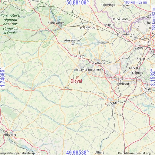
Diéval GPS coordinates[2]
50° 26' 7.26" North, 2° 27' 0.252" East
| Map corner | latitude | longitude |
|---|---|---|
| Upper-left | 50.88109°, | 1.74695° |
| Center: | 50.43535°, | 2.45007° |
| Lower-right: | 49.98538°, | 3.1532° |
| Map W x H: | 99.6×99.6 km | = 61.9×61.9mi |
| max Lat: | 51.07786° ⇑3.3% North |
| Diéval: | 50.43535° |
| min Lat: | ⇓96.7% South 41.3874° |
| min Long | Diéval | max Long |
| -5.08615° | 2.45007° | 9.52242° |
| W 49.8%⇐ | ⇒50.2% E |
Elevation
Elevation of Diéval is 130 m = 427 ft, and this is 63.7 m = 209 ft below average elevation for this country.
| Max E: |
2333 m = 7654 ft | 50.5% |
| Avg. | 193.7 m = 635 ft | |
| Diéval | 130 m = 427 ft | |
Min E: |
-1 m = -3 ft | 49.5% |
See also: France elevation on elevation.city.
Geographical zone
Diéval is located in North temperate zone (between Tropic of Cancer and the Arctic Circle). Distance of this North polar circle is 1793.3 km =1114.3 mi to North.| Distance of | km | miles | from Diéval |
|---|---|---|---|
| North Pole | 4399.2 | 2733.5 | to North |
| Arctic Circle | 1793.3 | 1114.3 | to North |
| Tropic Cancer | 3002 | 1865.4 | to South |
| Equator | 5607.9 | 3484.6 | to South |


Nearby cities:
15 places around Diéval: (largest is in red/bold)
• Auchel
7.8 km =4.8 mi,  12°
12°
• Bours
3.5 km =2.2 mi,  305°
305°
• Calonne-Ricouart
5.8 km =3.6 mi,  16°
16°
• Camblain-Châtelain
5.4 km =3.4 mi,  3°
3°
• Cauchy-à-la-Tour
7.6 km =4.7 mi,  357°
357°
• Divion
5.6 km =3.5 mi,  44°
44°
• Floringhem
7 km =4.3 mi,  345°
345°
• Houdain
6.4 km =4 mi,  74°
74°
• La Comté
3.1 km =1.9 mi,  110°
110°
• Magnicourt-en-Comte
5.3 km =3.3 mi,  138°
138°
• Ourton
3.3 km =2.1 mi, 42°
• Pernes
6.1 km =3.8 mi,  334°
334°
• Ranchicourt
7.6 km =4.7 mi,  89°
89°
• Roëllecourt
8.7 km =5.4 mi,  210°
210°
• Valhuon
5.1 km =3.2 mi,  267°
267°
Sources, notices
• [Note1] Compared only with cities in France existing in our database
• [Src1] Map data: © OpenStreetMap contributors (CC-BY-SA)
• [Src2] Other city data from geonames.org with taken over terms of usage.
• [Src3] Geographical zone / Annual Mean Temperature by Robert A. Rohde @ Wikipedia
