Falaise geodata
Falaise (Normandy) is a populated place; located in France in Europe/Paris (GMT+2) time zone. With population of 9,107 people, there are 1055 cities with bigger population in this country. Compared to other cities in France, 77.4% of cities are located further ↓South; 79.6% of cities are located further →East and 52.8% of cities have lower elevation than Falaise. Note1
Administrative division(s):
- Level 1: Normandy
- Level 2: Calvados
- Level 3: Arrondissement de Caen
- Level 4: Falaise


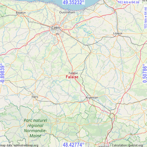
Falaise GPS coordinates[2]
48° 53' 31.812" North, 0° 11' 42.972" West
| Map corner | latitude | longitude |
|---|---|---|
| Upper-left | 49.35232°, | -0.89839° |
| Center: | 48.89217°, | -0.19527° |
| Lower-right: | 48.42774°, | 0.50786° |
| Map W x H: | 102.8×102.8 km | = 63.9×63.9mi |
| max Lat: | 51.07786° ⇑22.6% North |
| Falaise: | 48.89217° |
| min Lat: | ⇓77.4% South 41.3874° |
| min Long | Falaise | max Long |
| -5.08615° | -0.19527° | 9.52242° |
| W 20.4%⇐ | ⇒79.6% E |
Elevation
Elevation of Falaise is 142 m = 466 ft, and this is 51.7 m = 170 ft below average elevation for this country.
| Max E: |
2333 m = 7654 ft | 47.2% |
| Avg. | 193.7 m = 635 ft | |
| Falaise | 142 m = 466 ft | |
Min E: |
-1 m = -3 ft | 52.8% |
See also: France elevation on elevation.city.
Geographical zone
Falaise is located in North temperate zone (between Tropic of Cancer and the Arctic Circle). Distance of this North polar circle is 1964.9 km =1220.9 mi to North.| Distance of | km | miles | from Falaise |
|---|---|---|---|
| North Pole | 4570.8 | 2840.2 | to North |
| Arctic Circle | 1964.9 | 1220.9 | to North |
| Tropic Cancer | 2830.4 | 1758.7 | to South |
| Equator | 5436.3 | 3378 | to South |


Nearby cities:
15 places around Falaise: (largest is in red/bold)
• Courteilles
13 km =8.1 mi,  181°
181°
• Grainville-Langannerie
14.4 km =8.9 mi,  336°
336°
• La Hoguette
3 km =1.9 mi,  126°
126°
• Morteaux-Coulibœuf
10.5 km =6.5 mi,  64°
64°
• Occagnes
15.4 km =9.6 mi,  144°
144°
• Ouilly-le-Tesson
10.7 km =6.6 mi,  349°
349°
• Pont-d'Ouilly
15.2 km =9.4 mi,  263°
263°
• Pont-Écrepin
14.7 km =9.1 mi,  194°
194°
• Potigny
9.2 km =5.7 mi, 338°
• Putanges-Pont-Écrepin
14.5 km =9 mi,  196°
196°
• Saint-Germain-le-Vasson
14.5 km =9 mi,  327°
327°
• Soumont-Saint-Quentin
10 km =6.2 mi, 343°
• Ussy
9 km =5.6 mi,  314°
314°
• Vendeuvre
14 km =8.7 mi,  38°
38°
• Villers-Canivet
7 km =4.3 mi,  320°
320°
Sources, notices
• [Note1] Compared only with cities in France existing in our database
• [Src1] Map data: © OpenStreetMap contributors (CC-BY-SA)
• [Src2] Other city data from geonames.org with taken over terms of usage.
• [Src3] Geographical zone / Annual Mean Temperature by Robert A. Rohde @ Wikipedia
