La Hoguette geodata
La Hoguette (Normandy) is a populated place; located in France in Europe/Paris (GMT+2) time zone. With population of 605 people, there are 13241 cities with bigger population in this country. Compared to other cities in France, 77.1% of cities are located further ↓South; 79.3% of cities are located further →East and 53.6% of cities have lower elevation than La Hoguette. Note1
Administrative division(s):
- Level 1: Normandy
- Level 2: Calvados
- Level 3: Arrondissement de Caen
- Level 4: La Hoguette


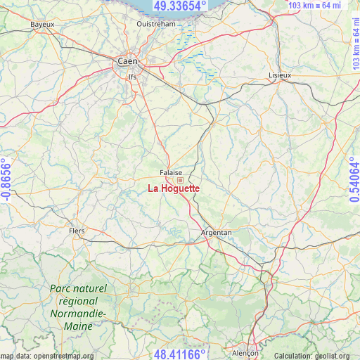
La Hoguette GPS coordinates[2]
48° 52' 34.464" North, 0° 9' 44.928" West
| Map corner | latitude | longitude |
|---|---|---|
| Upper-left | 49.33654°, | -0.8656° |
| Center: | 48.87624°, | -0.16248° |
| Lower-right: | 48.41166°, | 0.54064° |
| Map W x H: | 102.8×102.8 km | = 63.9×63.9mi |
| max Lat: | 51.07786° ⇑22.9% North |
| La Hoguette: | 48.87624° |
| min Lat: | ⇓77.1% South 41.3874° |
| min Long | La Hoguette | max Long |
| -5.08615° | -0.16248° | 9.52242° |
| W 20.7%⇐ | ⇒79.3% E |
Elevation
Elevation of La Hoguette is 145 m = 476 ft, and this is 48.7 m = 160 ft below average elevation for this country.
| Max E: |
2333 m = 7654 ft | 46.4% |
| Avg. | 193.7 m = 635 ft | |
| La Hoguette | 145 m = 476 ft | |
Min E: |
-1 m = -3 ft | 53.6% |
See also: France elevation on elevation.city.
Geographical zone
La Hoguette is located in North temperate zone (between Tropic of Cancer and the Arctic Circle). Distance of this North polar circle is 1966.6 km =1222 mi to North.| Distance of | km | miles | from La Hoguette |
|---|---|---|---|
| North Pole | 4572.5 | 2841.2 | to North |
| Arctic Circle | 1966.6 | 1222 | to North |
| Tropic Cancer | 2828.6 | 1757.6 | to South |
| Equator | 5434.5 | 3376.8 | to South |


Nearby cities:
15 places around La Hoguette: (largest is in red/bold)
• Bailleul
14.4 km =8.9 mi,  125°
125°
• Courteilles
11.6 km =7.2 mi,  193°
193°
• Falaise
3 km =1.9 mi,  306°
306°
• Grainville-Langannerie
17.1 km =10.6 mi,  331°
331°
• Morteaux-Coulibœuf
9.5 km =5.9 mi,  47°
47°
• Occagnes
12.6 km =7.8 mi,  148°
148°
• Ouilly-le-Tesson
13 km =8.1 mi,  340°
340°
• Pont-Écrepin
13.8 km =8.6 mi,  205°
205°
• Potigny
11.8 km =7.3 mi, 330°
• Putanges-Pont-Écrepin
13.8 km =8.6 mi, 207°
• Soumont-Saint-Quentin
12.5 km =7.8 mi, 335°
• Trun
14.8 km =9.2 mi,  104°
104°
• Ussy
12 km =7.5 mi, 312°
• Vendeuvre
14.2 km =8.8 mi,  26°
26°
• Villers-Canivet
9.9 km =6.2 mi,  316°
316°
Sources, notices
• [Note1] Compared only with cities in France existing in our database
• [Src1] Map data: © OpenStreetMap contributors (CC-BY-SA)
• [Src2] Other city data from geonames.org with taken over terms of usage.
• [Src3] Geographical zone / Annual Mean Temperature by Robert A. Rohde @ Wikipedia
