Sainte-Honorine-la-Chardonne geodata
Sainte-Honorine-la-Chardonne (Normandy) is a populated place; located in France in Europe/Paris (GMT+2) time zone. With population of 678 people, there are 12092 cities with bigger population in this country. Compared to other cities in France, 76.1% of cities are located further ↓South; 83.2% of cities are located further →East and 65.8% of cities have lower elevation than Sainte-Honorine-la-Chardonne. Note1
Administrative division(s):
- Level 1: Normandy
- Level 2: Département de l'Orne
- Level 3: Argentan
- Level 4: Sainte-Honorine-la-Chardonne
Current local time in Sainte-Honorine-la-Chardonne:
08:12 PM, SaturdayDifference from your time zone: hours


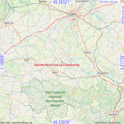
Sainte-Honorine-la-Chardonne GPS coordinates[2]
48° 49' 27.948" North, 0° 29' 8.7" West
| Map corner | latitude | longitude |
|---|---|---|
| Upper-left | 49.28521°, | -1.18888° |
| Center: | 48.82443°, | -0.48575° |
| Lower-right: | 48.35938°, | 0.21738° |
| Map W x H: | 102.9×102.9 km | = 63.9×63.9mi |
| max Lat: | 51.07786° ⇑23.9% North |
| Sainte-Honorine-la-Chardonne: | 48.82443° |
| min Lat: | ⇓76.1% South 41.3874° |
| min Long | Sainte-Honorine | max Long |
| -5.08615° | -0.48575° | 9.52242° |
| W 16.8%⇐ | ⇒83.2% E |
Elevation
Elevation of Sainte-Honorine-la-Chardonne is 198 m = 650 ft, and this is 4.3 m = 14 ft above average elevation for this country.
| Max E: |
2333 m = 7654 ft | 34.2% |
| Sainte-Honorine-la-Chardonne | 198 m 650 ft | |
| Avg. | 193.7 m = 635 ft | |
Min E: |
-1 m = -3 ft | 65.8% |
See also: France elevation on elevation.city.
Geographical zone
Sainte-Honorine-la-Chardonne is located in North temperate zone (between Tropic of Cancer and the Arctic Circle). Distance of this North polar circle is 1972.4 km =1225.6 mi to North.| Distance of | km | miles | from Sainte-Honorine-la-Chardonne |
|---|---|---|---|
| North Pole | 4578.3 | 2844.8 | to North |
| Arctic Circle | 1972.4 | 1225.6 | to North |
| Tropic Cancer | 2822.8 | 1754 | to South |
| Equator | 5428.8 | 3373.3 | to South |


Nearby cities:
15 places around Sainte-Honorine-la-Chardonne: (largest is in red/bold)
• Athis-de-l'Orne
1.4 km =0.9 mi,  230°
230°
• Berjou
2.8 km =1.7 mi,  7°
7°
• Caligny
8.2 km =5.1 mi,  257°
257°
• Clécy
10.3 km =6.4 mi,  2°
2°
• Condé-sur-Noireau
5.6 km =3.5 mi,  299°
299°
• Flers
11.7 km =7.3 mi,  213°
213°
• La Lande-Patry
10.8 km =6.7 mi, 230°
• La Selle-la-Forge
10.9 km =6.8 mi,  201°
201°
• Montilly-sur-Noireau
6.3 km =3.9 mi, 260°
• Pont-d'Ouilly
8.4 km =5.2 mi,  46°
46°
• Saint-Denis-de-Méré
5.5 km =3.4 mi,  335°
335°
• Saint-Georges-des-Groseillers
8.5 km =5.3 mi,  224°
224°
• Saint-Germain-du-Crioult
9.4 km =5.8 mi,  292°
292°
• Saint-Pierre-du-Regard
4.9 km =3 mi, 294°
• Saint-Rémy
12.9 km =8 mi,  354°
354°
Sources, notices
• [Note1] Compared only with cities in France existing in our database
• [Src1] Map data: © OpenStreetMap contributors (CC-BY-SA)
• [Src2] Other city data from geonames.org with taken over terms of usage.
• [Src3] Geographical zone / Annual Mean Temperature by Robert A. Rohde @ Wikipedia
