Argentan geodata
Argentan (Normandy) is a seat of a third-order administrative division; located in France in Europe/Paris (GMT+2) time zone. With population of 18,230 people, there are 521 cities with bigger population in this country. Compared to other cities in France, 74.2% of cities are located further ↓South; 78.3% of cities are located further →East and 57.4% of cities have lower elevation than Argentan. Note1
Administrative division(s):
- Level 1: Normandy
- Level 2: Département de l'Orne
- Level 3: Argentan
- Level 4: Argentan


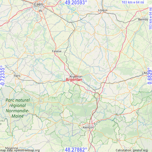
Argentan GPS coordinates[2]
48° 44' 39.876" North, 0° 1' 12.828" West
| Map corner | latitude | longitude |
|---|---|---|
| Upper-left | 49.20593°, | -0.72335° |
| Center: | 48.74441°, | -0.02023° |
| Lower-right: | 48.27862°, | 0.6829° |
| Map W x H: | 103.1×103.1 km | = 64.1×64.1mi |
| max Lat: | 51.07786° ⇑25.8% North |
| Argentan: | 48.74441° |
| min Lat: | ⇓74.2% South 41.3874° |
| min Long | Argentan | max Long |
| -5.08615° | -0.02023° | 9.52242° |
| W 21.7%⇐ | ⇒78.3% E |
Elevation
Elevation of Argentan is 159 m = 522 ft, and this is 34.7 m = 114 ft below average elevation for this country.
| Max E: |
2333 m = 7654 ft | 42.6% |
| Avg. | 193.7 m = 635 ft | |
| Argentan | 159 m = 522 ft | |
Min E: |
-1 m = -3 ft | 57.4% |
See also: France elevation on elevation.city.
Geographical zone
Argentan is located in North temperate zone (between Tropic of Cancer and the Arctic Circle). Distance of this North polar circle is 1981.3 km =1231.1 mi to North.| Distance of | km | miles | from Argentan |
|---|---|---|---|
| North Pole | 4587.2 | 2850.4 | to North |
| Arctic Circle | 1981.3 | 1231.1 | to North |
| Tropic Cancer | 2814 | 1748.5 | to South |
| Equator | 5419.9 | 3367.8 | to South |


Nearby cities:
15 places around Argentan: (largest is in red/bold)
• Almenêches
10.9 km =6.8 mi,  118°
118°
• Bailleul
6.4 km =4 mi,  11°
11°
• Boucé
12 km =7.5 mi,  205°
205°
• Courteilles
13.6 km =8.5 mi,  284°
284°
• La Hoguette
18 km =11.2 mi,  324°
324°
• Mortrée
13.8 km =8.6 mi,  148°
148°
• Nonant-le-Pin
18.1 km =11.2 mi,  103°
103°
• Occagnes
5.5 km =3.4 mi, 316°
• Pont-Écrepin
16.6 km =10.3 mi, 277°
• Putanges-Pont-Écrepin
17 km =10.6 mi, 278°
• Rânes
18.1 km =11.2 mi,  230°
230°
• Sarceaux
3.2 km =2 mi, 208°
• Trun
11.6 km =7.2 mi,  19°
19°
• Urou-et-Crennes
3 km =1.9 mi,  70°
70°
• Écouché
8.2 km =5.1 mi,  248°
248°
Sources, notices
• [Note1] Compared only with cities in France existing in our database
• [Src1] Map data: © OpenStreetMap contributors (CC-BY-SA)
• [Src2] Other city data from geonames.org with taken over terms of usage.
• [Src3] Geographical zone / Annual Mean Temperature by Robert A. Rohde @ Wikipedia
