Prat geodata
Prat (Brittany) is a populated place; located in France in Europe/Paris (GMT+2) time zone. With population of 1,049 people, there are 8470 cities with bigger population in this country. Compared to other cities in France, 72.7% of cities are located further ↓South; 97.9% of cities are located further →East and 69.2% of cities have higher elevation than Prat. Note1
Administrative division(s):
- Level 1: Brittany
- Level 2: Département des Côtes-d’Armor
- Level 3: Arrondissement de Lannion
- Level 4: Prat


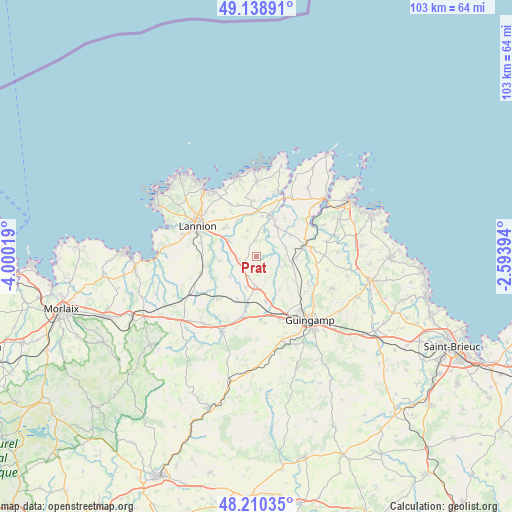
Prat GPS coordinates[2]
48° 40' 36.372" North, 3° 17' 49.452" West
| Map corner | latitude | longitude |
|---|---|---|
| Upper-left | 49.13891°, | -4.00019° |
| Center: | 48.67677°, | -3.29707° |
| Lower-right: | 48.21035°, | -2.59394° |
| Map W x H: | 103.2×103.2 km | = 64.1×64.1mi |
| max Lat: | 51.07786° ⇑27.3% North |
| Prat: | 48.67677° |
| min Lat: | ⇓72.7% South 41.3874° |
| min Long | Prat | max Long |
| -5.08615° | -3.29707° | 9.52242° |
| W 2.1%⇐ | ⇒97.9% E |
Elevation
Elevation of Prat is 80 m = 262 ft, and this is 113.7 m = 373 ft below average elevation for this country.
| Max E: |
2333 m = 7654 ft | 69.2% |
| Avg. | 193.7 m = 635 ft | |
| Prat | 80 m = 262 ft | |
Min E: |
-1 m = -3 ft | 30.8% |
See also: France elevation on elevation.city.
Geographical zone
Prat is located in North temperate zone (between Tropic of Cancer and the Arctic Circle). Distance of this North polar circle is 1988.8 km =1235.8 mi to North.| Distance of | km | miles | from Prat |
|---|---|---|---|
| North Pole | 4594.7 | 2855 | to North |
| Arctic Circle | 1988.8 | 1235.8 | to North |
| Tropic Cancer | 2806.4 | 1743.8 | to South |
| Equator | 5412.3 | 3363 | to South |


Nearby cities:
15 places around Prat: (largest is in red/bold)
• Bégard
5.5 km =3.4 mi,  182°
182°
• Camlez
11.3 km =7 mi,  357°
357°
• Caouënnec-Lanvézéac
5.7 km =3.5 mi,  296°
296°
• Cavan
3.6 km =2.2 mi,  262°
262°
• La Roche-Derrien
8.2 km =5.1 mi,  18°
18°
• Langoat
8.3 km =5.2 mi,  8°
8°
• Ploubezre
11.5 km =7.1 mi,  282°
282°
• Plouëc-du-Trieux
7.2 km =4.5 mi,  84°
84°
• Ploëzal
8.1 km =5 mi,  58°
58°
• Pluzunet
6.8 km =4.2 mi,  233°
233°
• Pommerit-Jaudy
7.2 km =4.5 mi,  33°
33°
• Pontrieux
10.4 km =6.5 mi,  74°
74°
• Pédernec
9.1 km =5.7 mi,  167°
167°
• Rospez
8.6 km =5.3 mi,  312°
312°
• Tonquédec
7.4 km =4.6 mi, 263°
Sources, notices
• [Note1] Compared only with cities in France existing in our database
• [Src1] Map data: © OpenStreetMap contributors (CC-BY-SA)
• [Src2] Other city data from geonames.org with taken over terms of usage.
• [Src3] Geographical zone / Annual Mean Temperature by Robert A. Rohde @ Wikipedia
