Chavagnes-les-Redoux geodata
Chavagnes-les-Redoux (Pays de la Loire) is a populated place; located in France in Europe/Paris (GMT+2) time zone. With population of 785 people, there are 10762 cities with bigger population in this country. Compared to other cities in France, 58.1% of cities are located further ↑North; 87.5% of cities are located further →East and 58.7% of cities have higher elevation than Chavagnes-les-Redoux. Note1
Administrative division(s):
- Level 1: Pays de la Loire
- Level 2: Département de la Vendée
- Level 3: Arrondissement de Fontenay-le-Comte
- Level 4: Chavagnes-les-Redoux


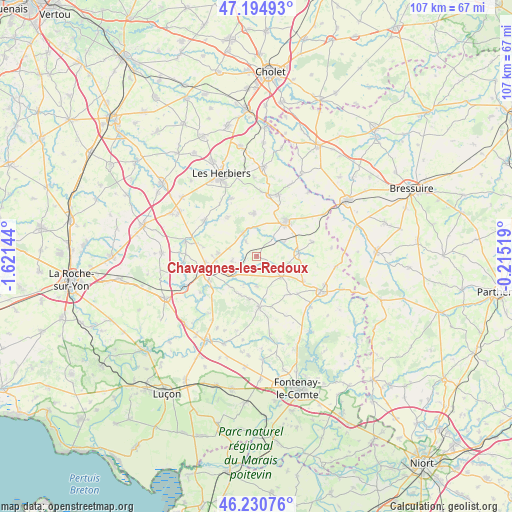
Chavagnes-les-Redoux GPS coordinates[2]
46° 42' 54" North, 0° 55' 5.952" West
| Map corner | latitude | longitude |
|---|---|---|
| Upper-left | 47.19493°, | -1.62144° |
| Center: | 46.715°, | -0.91832° |
| Lower-right: | 46.23076°, | -0.21519° |
| Map W x H: | 107.2×107.2 km | = 66.6×66.6mi |
| max Lat: | 51.07786° ⇑58.1% North |
| Chavagnes-les-Redoux: | 46.715° |
| min Lat: | ⇓41.9% South 41.3874° |
| min Long | Chavagnes-les-R | max Long |
| -5.08615° | -0.91832° | 9.52242° |
| W 12.5%⇐ | ⇒87.5% E |
Elevation
Elevation of Chavagnes-les-Redoux is 106 m = 348 ft, and this is 87.7 m = 288 ft below average elevation for this country.
| Max E: |
2333 m = 7654 ft | 58.7% |
| Avg. | 193.7 m = 635 ft | |
| Chavagnes-les-Redoux | 106 m = 348 ft | |
Min E: |
-1 m = -3 ft | 41.3% |
See also: France elevation on elevation.city.
Geographical zone
Chavagnes-les-Redoux is located in North temperate zone (between Tropic of Cancer and the Arctic Circle). Distance of this North polar circle is 2207 km =1371.4 mi to North.| Distance of | km | miles | from Chavagnes-les-Redoux |
|---|---|---|---|
| North Pole | 4812.8 | 2990.5 | to North |
| Arctic Circle | 2207 | 1371.4 | to North |
| Tropic Cancer | 2588.3 | 1608.3 | to South |
| Equator | 5194.2 | 3227.5 | to South |


Nearby cities:
15 places around Chavagnes-les-Redoux: (largest is in red/bold)
• Bazoges-en-Pareds
6.4 km =4 mi,  178°
178°
• Chantonnay
10.5 km =6.5 mi,  252°
252°
• Cheffois
11.1 km =6.9 mi,  117°
117°
• La Jaudonnière
8.7 km =5.4 mi,  202°
202°
• La Meilleraie-Tillay
6.3 km =3.9 mi,  63°
63°
• Le Boupère
9 km =5.6 mi,  356°
356°
• Monsireigne
4 km =2.5 mi,  323°
323°
• Mouilleron-en-Pareds
6.8 km =4.2 mi,  129°
129°
• Pouzauges
9.5 km =5.9 mi,  41°
41°
• Rochetrejoux
10.2 km =6.3 mi, 324°
• Réaumur
8.8 km =5.5 mi,  86°
86°
• Saint-Germain-de-Prinçay
7.9 km =4.9 mi,  274°
274°
• Saint-Prouant
5.6 km =3.5 mi,  328°
328°
• Sigournais
5.2 km =3.2 mi,  260°
260°
• Thouarsais-Bouildroux
11 km =6.8 mi,  164°
164°
Sources, notices
• [Note1] Compared only with cities in France existing in our database
• [Src1] Map data: © OpenStreetMap contributors (CC-BY-SA)
• [Src2] Other city data from geonames.org with taken over terms of usage.
• [Src3] Geographical zone / Annual Mean Temperature by Robert A. Rohde @ Wikipedia
