Pougues-les-Eaux geodata
Pougues-les-Eaux (Bourgogne-Franche-Comté) is a populated place; located in France in Europe/Paris (GMT+2) time zone. With population of 2,500 people, there are 3893 cities with bigger population in this country. Compared to other cities in France, 54.5% of cities are located further ↑North; 59.3% of cities are located further ←West and 66.4% of cities have lower elevation than Pougues-les-Eaux. Note1
Administrative division(s):
- Level 1: Bourgogne-Franche-Comté
- Level 2: Département de la Nièvre
- Level 3: Arrondissement de Nevers
- Level 4: Pougues-les-Eaux


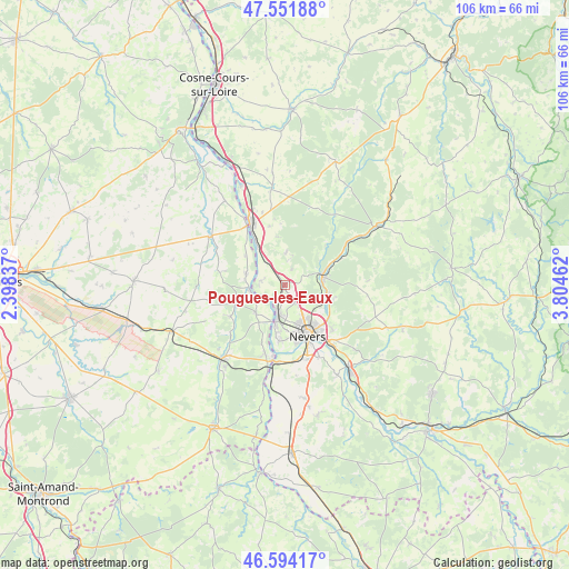
Pougues-les-Eaux GPS coordinates[2]
47° 4' 30.648" North, 3° 6' 5.4" East
| Map corner | latitude | longitude |
|---|---|---|
| Upper-left | 47.55188°, | 2.39837° |
| Center: | 47.07518°, | 3.1015° |
| Lower-right: | 46.59417°, | 3.80462° |
| Map W x H: | 106.5×106.5 km | = 66.2×66.2mi |
| max Lat: | 51.07786° ⇑54.5% North |
| Pougues-les-Eaux: | 47.07518° |
| min Lat: | ⇓45.5% South 41.3874° |
| min Long | Pougues-les-Eau | max Long |
| -5.08615° | 3.1015° | 9.52242° |
| W 59.3%⇐ | ⇒40.7% E |
Elevation
Elevation of Pougues-les-Eaux is 201 m = 659 ft, and this is 7.3 m = 24 ft above average elevation for this country.
| Max E: |
2333 m = 7654 ft | 33.6% |
| Pougues-les-Eaux | 201 m 659 ft | |
| Avg. | 193.7 m = 635 ft | |
Min E: |
-1 m = -3 ft | 66.4% |
See also: France elevation on elevation.city.
Geographical zone
Pougues-les-Eaux is located in North temperate zone (between Tropic of Cancer and the Arctic Circle). Distance of this North polar circle is 2166.9 km =1346.4 mi to North.| Distance of | km | miles | from Pougues-les-Eaux |
|---|---|---|---|
| North Pole | 4772.8 | 2965.7 | to North |
| Arctic Circle | 2166.9 | 1346.4 | to North |
| Tropic Cancer | 2628.4 | 1633.2 | to South |
| Equator | 5234.3 | 3252.4 | to South |


Nearby cities:
15 places around Pougues-les-Eaux: (largest is in red/bold)
• Beffes
7.3 km =4.5 mi,  286°
286°
• Chaulgnes
6 km =3.7 mi,  1°
1°
• Coulanges-lès-Nevers
10.2 km =6.3 mi,  140°
140°
• Cours-les-Barres
7.7 km =4.8 mi,  223°
223°
• Fourchambault
6.6 km =4.1 mi,  191°
191°
• Garchizy
3.1 km =1.9 mi, 187°
• Germigny-sur-Loire
5.2 km =3.2 mi,  279°
279°
• Guérigny
7.7 km =4.8 mi,  80°
80°
• Jouet-sur-l'Aubois
9.3 km =5.8 mi,  249°
249°
• La Marche
8.8 km =5.5 mi,  324°
324°
• Marseilles-lès-Aubigny
6.9 km =4.3 mi,  262°
262°
• Nevers
10.5 km =6.5 mi,  155°
155°
• Parigny-les-Vaux
4 km =2.5 mi,  63°
63°
• Urzy
8.2 km =5.1 mi,  110°
110°
• Varennes-Vauzelles
7.1 km =4.4 mi, 155°
Sources, notices
• [Note1] Compared only with cities in France existing in our database
• [Src1] Map data: © OpenStreetMap contributors (CC-BY-SA)
• [Src2] Other city data from geonames.org with taken over terms of usage.
• [Src3] Geographical zone / Annual Mean Temperature by Robert A. Rohde @ Wikipedia
