Guérigny geodata
Guérigny (Bourgogne-Franche-Comté) is a populated place; located in France in Europe/Paris (GMT+2) time zone. With population of 2,486 people, there are 3908 cities with bigger population in this country. Compared to other cities in France, 54.4% of cities are located further ↑North; 60.6% of cities are located further ←West and 71.4% of cities have lower elevation than Guérigny. Note1
Administrative division(s):
- Level 1: Bourgogne-Franche-Comté
- Level 2: Département de la Nièvre
- Level 3: Arrondissement de Nevers
- Level 4: Guérigny


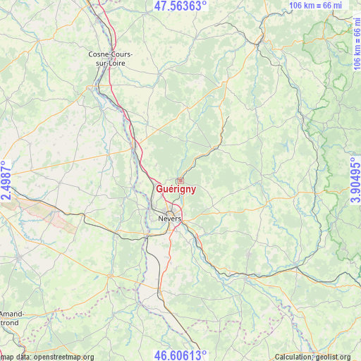
Guérigny GPS coordinates[2]
47° 5' 13.308" North, 3° 12' 6.552" East
| Map corner | latitude | longitude |
|---|---|---|
| Upper-left | 47.56363°, | 2.4987° |
| Center: | 47.08703°, | 3.20182° |
| Lower-right: | 46.60613°, | 3.90495° |
| Map W x H: | 106.5×106.5 km | = 66.2×66.2mi |
| max Lat: | 51.07786° ⇑54.4% North |
| Guérigny: | 47.08703° |
| min Lat: | ⇓45.6% South 41.3874° |
| min Long | Guérigny | max Long |
| -5.08615° | 3.20182° | 9.52242° |
| W 60.6%⇐ | ⇒39.4% E |
Elevation
Elevation of Guérigny is 226 m = 741 ft, and this is 32.3 m = 106 ft above average elevation for this country.
| Max E: |
2333 m = 7654 ft | 28.6% |
| Guérigny | 226 m 741 ft | |
| Avg. | 193.7 m = 635 ft | |
Min E: |
-1 m = -3 ft | 71.4% |
See also: France elevation on elevation.city.
Geographical zone
Guérigny is located in North temperate zone (between Tropic of Cancer and the Arctic Circle). Distance of this North polar circle is 2165.6 km =1345.6 mi to North.| Distance of | km | miles | from Guérigny |
|---|---|---|---|
| North Pole | 4771.5 | 2964.9 | to North |
| Arctic Circle | 2165.6 | 1345.6 | to North |
| Tropic Cancer | 2629.7 | 1634 | to South |
| Equator | 5235.6 | 3253.3 | to South |


Nearby cities:
15 places around Guérigny: (largest is in red/bold)
• Chaulgnes
8.8 km =5.5 mi,  302°
302°
• Coulanges-lès-Nevers
9.2 km =5.7 mi,  186°
186°
• Fourchambault
11.9 km =7.4 mi,  228°
228°
• Garchizy
9.1 km =5.7 mi,  241°
241°
• Germigny-sur-Loire
12.8 km =8 mi,  268°
268°
• La Marche
14 km =8.7 mi,  294°
294°
• Marzy
14.3 km =8.9 mi,  214°
214°
• Montigny-aux-Amognes
9.4 km =5.8 mi,  134°
134°
• Nevers
11.3 km =7 mi,  196°
196°
• Parigny-les-Vaux
4 km =2.5 mi,  277°
277°
• Pougues-les-Eaux
7.7 km =4.8 mi,  260°
260°
• Prémery
13.2 km =8.2 mi,  46°
46°
• Saint-Éloi
12.7 km =7.9 mi,  173°
173°
• Urzy
4.3 km =2.7 mi,  178°
178°
• Varennes-Vauzelles
9.1 km =5.7 mi, 210°
Sources, notices
• [Note1] Compared only with cities in France existing in our database
• [Src1] Map data: © OpenStreetMap contributors (CC-BY-SA)
• [Src2] Other city data from geonames.org with taken over terms of usage.
• [Src3] Geographical zone / Annual Mean Temperature by Robert A. Rohde @ Wikipedia
