Pontcarré geodata
Pontcarré (Île-de-France) is a populated place; located in France in Europe/Paris (GMT+2) time zone. With population of 1,980 people, there are 4834 cities with bigger population in this country. Compared to other cities in France, 75.5% of cities are located further ↓South; 53.6% of cities are located further ←West and 55.2% of cities have higher elevation than Pontcarré. Note1
Administrative division(s):
- Level 1: Île-de-France
- Level 2: Seine-et-Marne
- Level 3: Arrondissement de Provins
- Level 4: Pontcarré


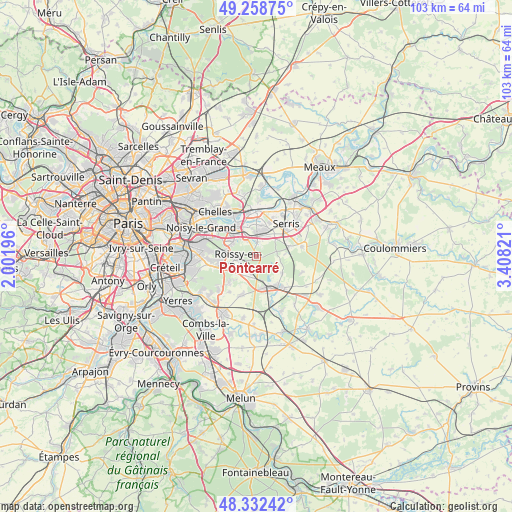
Pontcarré GPS coordinates[2]
48° 47' 51.792" North, 2° 42' 18.288" East
| Map corner | latitude | longitude |
|---|---|---|
| Upper-left | 49.25875°, | 2.00196° |
| Center: | 48.79772°, | 2.70508° |
| Lower-right: | 48.33242°, | 3.40821° |
| Map W x H: | 103×103 km | = 64×64mi |
| max Lat: | 51.07786° ⇑24.5% North |
| Pontcarré: | 48.79772° |
| min Lat: | ⇓75.5% South 41.3874° |
| min Long | Pontcarré | max Long |
| -5.08615° | 2.70508° | 9.52242° |
| W 53.6%⇐ | ⇒46.4% E |
Elevation
Elevation of Pontcarré is 116 m = 381 ft, and this is 77.7 m = 255 ft below average elevation for this country.
| Max E: |
2333 m = 7654 ft | 55.2% |
| Avg. | 193.7 m = 635 ft | |
| Pontcarré | 116 m = 381 ft | |
Min E: |
-1 m = -3 ft | 44.8% |
See also: France elevation on elevation.city.
Geographical zone
Pontcarré is located in North temperate zone (between Tropic of Cancer and the Arctic Circle). Distance of this North polar circle is 1975.4 km =1227.5 mi to North.| Distance of | km | miles | from Pontcarré |
|---|---|---|---|
| North Pole | 4581.3 | 2846.7 | to North |
| Arctic Circle | 1975.4 | 1227.5 | to North |
| Tropic Cancer | 2819.9 | 1752.2 | to South |
| Equator | 5425.8 | 3371.4 | to South |


Nearby cities:
15 places around Pontcarré: (largest is in red/bold)
• Bussy-Saint-Georges
4.8 km =3 mi,  357°
357°
• Bussy-Saint-Martin
5.8 km =3.6 mi,  349°
349°
• Chanteloup-en-Brie
6.8 km =4.2 mi,  21°
21°
• Collégien
4.8 km =3 mi,  331°
331°
• Conches-sur-Gondoire
6.6 km =4.1 mi,  8°
8°
• Croissy-Beaubourg
4.3 km =2.7 mi,  322°
322°
• Favières
6.4 km =4 mi,  126°
126°
• Ferrières-en-Brie
2.9 km =1.8 mi,  2°
2°
• Gretz-Armainvilliers
6.6 km =4.1 mi,  163°
163°
• Guermantes
6.1 km =3.8 mi, 359°
• Jossigny
5.7 km =3.5 mi,  39°
39°
• Ozoir-la-Ferrière
4.3 km =2.7 mi,  217°
217°
• Roissy-en-Brie
4.3 km =2.7 mi,  260°
260°
• Villeneuve-Saint-Denis
6.8 km =4.2 mi,  72°
72°
• Émerainville
6.4 km =4 mi,  285°
285°
Sources, notices
• [Note1] Compared only with cities in France existing in our database
• [Src1] Map data: © OpenStreetMap contributors (CC-BY-SA)
• [Src2] Other city data from geonames.org with taken over terms of usage.
• [Src3] Geographical zone / Annual Mean Temperature by Robert A. Rohde @ Wikipedia
