Mécleuves geodata
Mécleuves (Grand Est) is a populated place; located in France in Europe/Paris (GMT+2) time zone. With population of 1,040 people, there are 8540 cities with bigger population in this country. Compared to other cities in France, 80.7% of cities are located further ↓South; 89.9% of cities are located further ←West and 70.1% of cities have lower elevation than Mécleuves. Note1
Administrative division(s):
- Level 1: Grand Est
- Level 2: Moselle
- Level 3: Arrondissement de Metz
- Level 4: Mécleuves


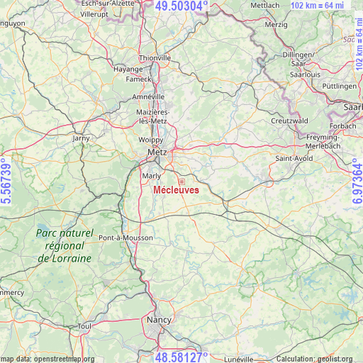
Mécleuves GPS coordinates[2]
49° 2' 39.444" North, 6° 16' 13.836" East
| Map corner | latitude | longitude |
|---|---|---|
| Upper-left | 49.50304°, | 5.56739° |
| Center: | 49.04429°, | 6.27051° |
| Lower-right: | 48.58127°, | 6.97364° |
| Map W x H: | 102.5×102.5 km | = 63.7×63.7mi |
| max Lat: | 51.07786° ⇑19.3% North |
| Mécleuves: | 49.04429° |
| min Lat: | ⇓80.7% South 41.3874° |
| min Long | Mécleuves | max Long |
| -5.08615° | 6.27051° | 9.52242° |
| W 89.9%⇐ | ⇒10.1% E |
Elevation
Elevation of Mécleuves is 220 m = 722 ft, and this is 26.3 m = 86 ft above average elevation for this country.
| Max E: |
2333 m = 7654 ft | 29.9% |
| Mécleuves | 220 m 722 ft | |
| Avg. | 193.7 m = 635 ft | |
Min E: |
-1 m = -3 ft | 70.1% |
See also: France elevation on elevation.city.
Geographical zone
Mécleuves is located in North temperate zone (between Tropic of Cancer and the Arctic Circle). Distance of this North polar circle is 1948 km =1210.4 mi to North.| Distance of | km | miles | from Mécleuves |
|---|---|---|---|
| North Pole | 4553.8 | 2829.6 | to North |
| Arctic Circle | 1948 | 1210.4 | to North |
| Tropic Cancer | 2847.3 | 1769.2 | to South |
| Equator | 5453.2 | 3388.5 | to South |


Nearby cities:
15 places around Mécleuves: (largest is in red/bold)
• Ars-Laquenexy
5.5 km =3.4 mi,  359°
359°
• Coin-lès-Cuvry
8.4 km =5.2 mi,  262°
262°
• Courcelles-sur-Nied
3.7 km =2.3 mi,  48°
48°
• Cuvry
8.1 km =5 mi,  269°
269°
• Fleury
5.6 km =3.5 mi, 267°
• Jury
3.1 km =1.9 mi,  335°
335°
• Laquenexy
5 km =3.1 mi,  40°
40°
• Marly
8.7 km =5.4 mi,  284°
284°
• Pange
7.6 km =4.7 mi, 53°
• Peltre
4.6 km =2.9 mi,  317°
317°
• Pommérieux
8.8 km =5.5 mi,  233°
233°
• Pouilly
6.2 km =3.9 mi, 275°
• Pournoy-la-Chétive
8.9 km =5.5 mi,  251°
251°
• Solgne
8.9 km =5.5 mi,  168°
168°
• Verny
6.4 km =4 mi, 229°
Sources, notices
• [Note1] Compared only with cities in France existing in our database
• [Src1] Map data: © OpenStreetMap contributors (CC-BY-SA)
• [Src2] Other city data from geonames.org with taken over terms of usage.
• [Src3] Geographical zone / Annual Mean Temperature by Robert A. Rohde @ Wikipedia
