Piolenc geodata
Piolenc (Provence-Alpes-Côte d'Azur) is a populated place; located in France in Europe/Paris (GMT+2) time zone. With population of 4,606 people, there are 2144 cities with bigger population in this country. Compared to other cities in France, 85.7% of cities are located further ↑North; 74.5% of cities are located further ←West and 85.3% of cities have higher elevation than Piolenc. Note1
Administrative division(s):
- Level 1: Provence-Alpes-Côte d'Azur
- Level 2: Département du Vaucluse
- Level 3: Arrondissement de Carpentras
- Level 4: Piolenc


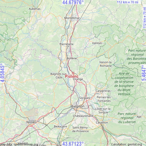
Piolenc GPS coordinates[2]
44° 10' 39.54" North, 4° 45' 41.652" East
| Map corner | latitude | longitude |
|---|---|---|
| Upper-left | 44.67976°, | 4.05845° |
| Center: | 44.17765°, | 4.76157° |
| Lower-right: | 43.67123°, | 5.4647° |
| Map W x H: | 112.1×112.1 km | = 69.7×69.7mi |
| max Lat: | 51.07786° ⇑85.7% North |
| Piolenc: | 44.17765° |
| min Lat: | ⇓14.3% South 41.3874° |
| min Long | Piolenc | max Long |
| -5.08615° | 4.76157° | 9.52242° |
| W 74.5%⇐ | ⇒25.5% E |
Elevation
Elevation of Piolenc is 41 m = 135 ft, and this is 152.7 m = 501 ft below average elevation for this country.
| Max E: |
2333 m = 7654 ft | 85.3% |
| Avg. | 193.7 m = 635 ft | |
| Piolenc | 41 m = 135 ft | |
Min E: |
-1 m = -3 ft | 14.7% |
See also: France elevation on elevation.city.
Geographical zone
Piolenc is located in North temperate zone (between Tropic of Cancer and the Arctic Circle). Distance of this Northern Tropic circle is 2306.2 km =1433 mi to South.| Distance of | km | miles | from Piolenc |
|---|---|---|---|
| North Pole | 5095 | 3165.9 | to North |
| Arctic Circle | 2489.1 | 1546.7 | to North |
| Tropic Cancer | 2306.2 | 1433 | to South |
| Equator | 4912.1 | 3052.2 | to South |


Nearby cities:
15 places around Piolenc: (largest is in red/bold)
• Caderousse
8.3 km =5.2 mi,  182°
182°
• Camaret-sur-Aigues
9 km =5.6 mi,  99°
99°
• Chusclan
7.2 km =4.5 mi,  242°
242°
• Codolet
7.9 km =4.9 mi,  220°
220°
• Mondragon
7.8 km =4.8 mi,  330°
330°
• Mornas
3.9 km =2.4 mi,  315°
315°
• Orange
5.9 km =3.7 mi,  138°
138°
• Orsan
9.3 km =5.8 mi, 236°
• Rochegude
9.1 km =5.7 mi,  35°
35°
• Saint-Nazaire
11.2 km =7 mi,  281°
281°
• Saint-Étienne-des-Sorts
4.5 km =2.8 mi, 281°
• Sérignan-du-Comtat
6.7 km =4.2 mi,  78°
78°
• Travaillan
11.1 km =6.9 mi,  86°
86°
• Uchaux
5.3 km =3.3 mi, 35°
• Vénéjan
8.8 km =5.5 mi, 284°
Sources, notices
• [Note1] Compared only with cities in France existing in our database
• [Src1] Map data: © OpenStreetMap contributors (CC-BY-SA)
• [Src2] Other city data from geonames.org with taken over terms of usage.
• [Src3] Geographical zone / Annual Mean Temperature by Robert A. Rohde @ Wikipedia
